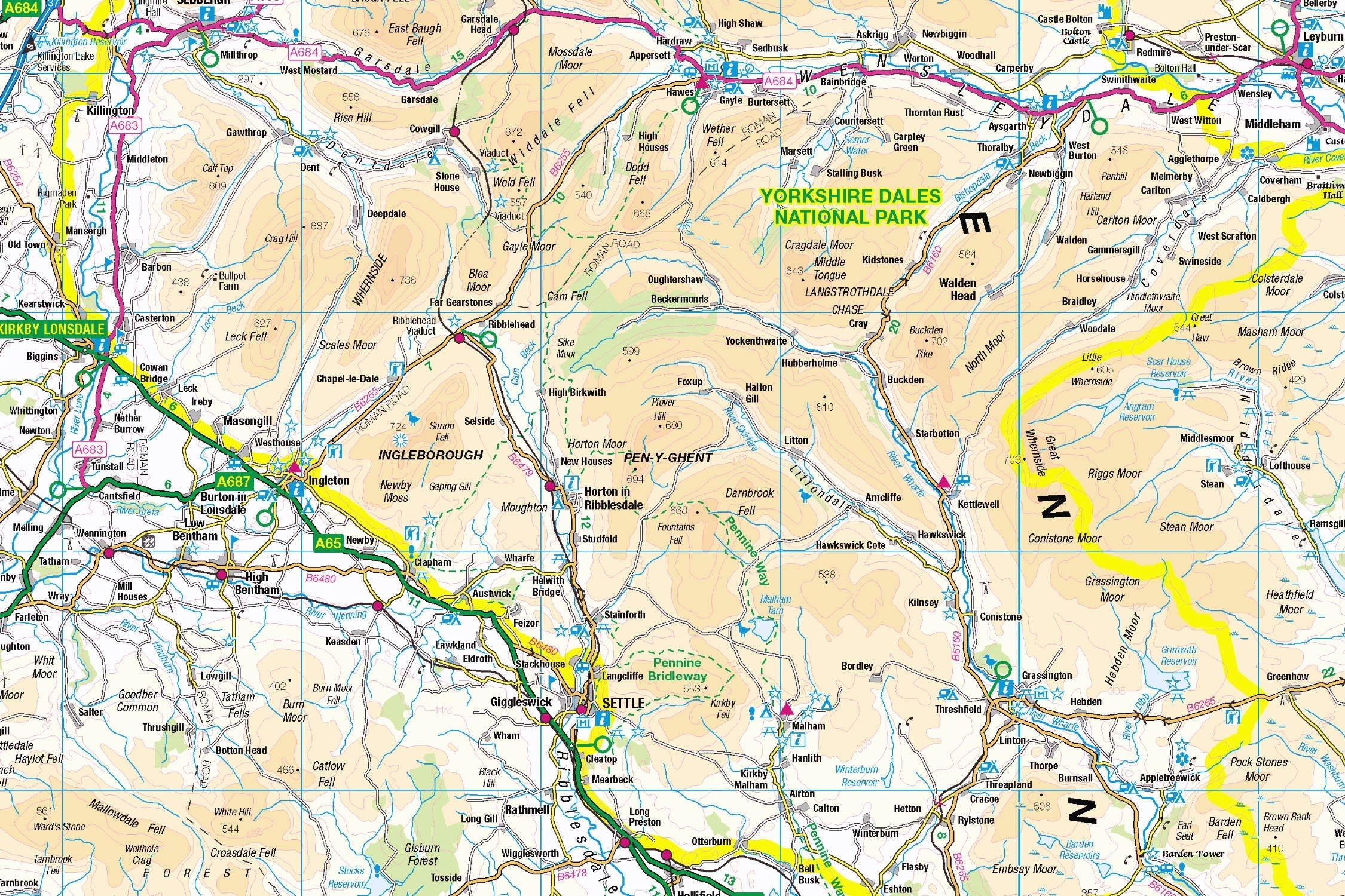
Puzzle Your Way Through the Yorkshire Dales: An OS Map Adventure
Discover Limestone Landscapes & Charming Dales, One Piece at a Time
Key Highlights
-
UNESCO Status: Part of the World Heritage-listed Yorkshire Dales
-
Precision Mapping: OS 1:250,000 scale roadmap revealing all villages & park boundaries
-
1,000-Piece Challenge: 69cm x 48cm completed size
-
Open Government Licence: Officially accredited OS data
-
Mindful Exploration: Combines geography education with relaxing puzzling
Introducing the Yorkshire Dales Map Jigsaw
Pieceful Maps invites you to piece together England’s most iconic limestone landscape with our Yorkshire Dales Map Jigsaw. This 1,000-piece puzzle (69cm x 48cm assembled) transforms Ordnance Survey’s definitive 1:250,000 roadmap into an immersive journey through winding valleys, historic market towns, and the park’s precise boundaries. Created under the Open Government Licence, every road, settlement, and landmark is reproduced with cartographic accuracy – perfect for planning adventures or simply indulging in mindful puzzling.
Why This Scale Wins:
-
Complete Park Coverage: Entire 841 square miles in one view
-
Settlement Clarity: Every village from Reeth to Dent clearly visible
-
Road Network Focus: Colour-coded routes simplify navigation and puzzle assembly
-
Boundary Precision: National Park edges marked for easy orientation
The Yorkshire Dales: Limestone Legacy
A Landscape of Contrasts
Designated in 1954, the Yorkshire Dales National Park stretches across 2,179 km² of Northern England, famed for its glacial valleys (dales), subterranean caves, and traditional field barns. Its 2016 UNESCO World Heritage status recognises the unique interplay of natural beauty and centuries-old farming traditions.
Essential Dales Data:
| Feature | Detail |
|---|---|
| Size | 841 square miles |
| Key Rivers | Swale, Ure, Wharfe, Ribble |
| Famous Landmarks | Malham Cove, Aysgarth Falls |
| Annual Visitors | Over 4 million |
| Unique Geology | Limestone pavements & shakeholes |
Navigational Treasures
Assemble your puzzle to uncover these iconic features:
-
Market Towns: Grassington (cultural hub), Hawes (home of Wensleydale cheese), Settle (Victorian railway gateway)
-
Rivers & Roads: The A684 (scenic east-west artery), B6160 (Bolton Abbey approach), and the serpentine River Wharfe
-
Cultural Icons: Ribblehead Viaduct (24 majestic arches), Fountains Abbey (UNESCO monastic ruins), Wensleydale Creamery
Mastering Road Map Puzzling
Strategic Assembly Guide
Road maps offer unique solving advantages with their linear networks and colour coding:
-
Boundary First: Connect the distinctive national park border
-
A-Road Anchors: Assemble A-roads (A65, A684) as structural spines
-
River Routes: Piece together waterways radiating like veins from the Three Peaks
-
Settlement Clusters: Build market towns first, then connect satellite villages
-
Symbol Highlights: Add tourist icons (castle symbols, parking areas, viewpoints)
Cognitive Benefits:
-
Spatial Intelligence: Visualising how Settle links to Skipton via the A65
-
Pattern Recognition: Identifying B-road vs minor road hierarchies
-
Memory Exercise: Recalling relative positions of key valleys (Swaledale vs Wensleydale)
-
Mindful Focus: Achieving "flow state" during road-tracing sessions
Ordnance Survey: The Gold Standard
Why OS Road Maps Shine
Our puzzles use official 1:250,000 data – the ideal scale for national park overviews:
-
Settlement Clarity: All 50+ villages labelled without clutter
-
Navigation-Ready: Road classifications mirror real-world signage
-
Tourist Friendly: Highlights attractions, parking, and visitor centres
-
Boundary Accuracy: Exact park perimeters marked
"Contains public sector information licensed under the Open Government Licence - os.uk/opendata/licence"
The Pieceful Maps Experience
Premium Craftsmanship
-
Snug-fitting pieces with zero false fits
Top Real-World Experiences:
-
Three Peaks Circuit: Hike Pen-y-ghent, Whernside, and Ingleborough (39km challenge)
-
Cheese Trail: Tour Wensleydale Creamery followed by Hawes village pubs
-
Rail Adventure: Ride the Settle-Carlisle Railway through Ribblehead Viaduct
-
Hidden Gem: Janet’s Foss waterfall near Malham – a magical woodland walk
Why Puzzle Fans Adore This Map
"The Yorkshire Dales puzzle turns armchair travel into geographical mastery. Where else can you trace the River Swale from source to lowlands, locate every cheese-making village, and spot the perfect pub lunch stop – all while drinking Yorkshire Tea?" – Pieceful Maps Designer
The Mindful Mapping Journey
This 1,000-piece challenge delivers:
-
Digital Detox: 8-12 hours of screen-free immersion
-
Family Bonding: Collaborative navigation fun for all ages
-
Skill Development: Map literacy and spatial reasoning
-
Achievement High: Dopamine release upon completing the Dales
-
Wall Art Reward: Stunning display piece for homes or offices
Ready to navigate England’s limestone wonderland? The Yorkshire Dales await – one piece at a time.
About Pieceful Maps: We transform official Ordnance Survey data into captivating jigsaws celebrating Britain’s national parks.
Latest Product Reviews
A Proud Kase UK Partner
The use of high quality glass filters for landscape photography is quite simply game changing and will improve your resulting images. I am happy to talk filters and help you get started, start a conversation here


