


Discover the Lake District: Your OS Road Map Jigsaw Adventure
Piece Together England's Mountain Majesty
Key Takeaways
-
Iconic mountainous region with 16 million annual visitors
-
Precision Ordnance Survey mapping at 1:250,000 scale
-
1000-piece challenge revealing towns, roads & park boundaries
-
Crafted using official Ordnance Survey Mapping Data Open Government Licence data
-
Perfect blend of geographical education & mindful puzzling
Introducing the Lake District Map Jigsaw
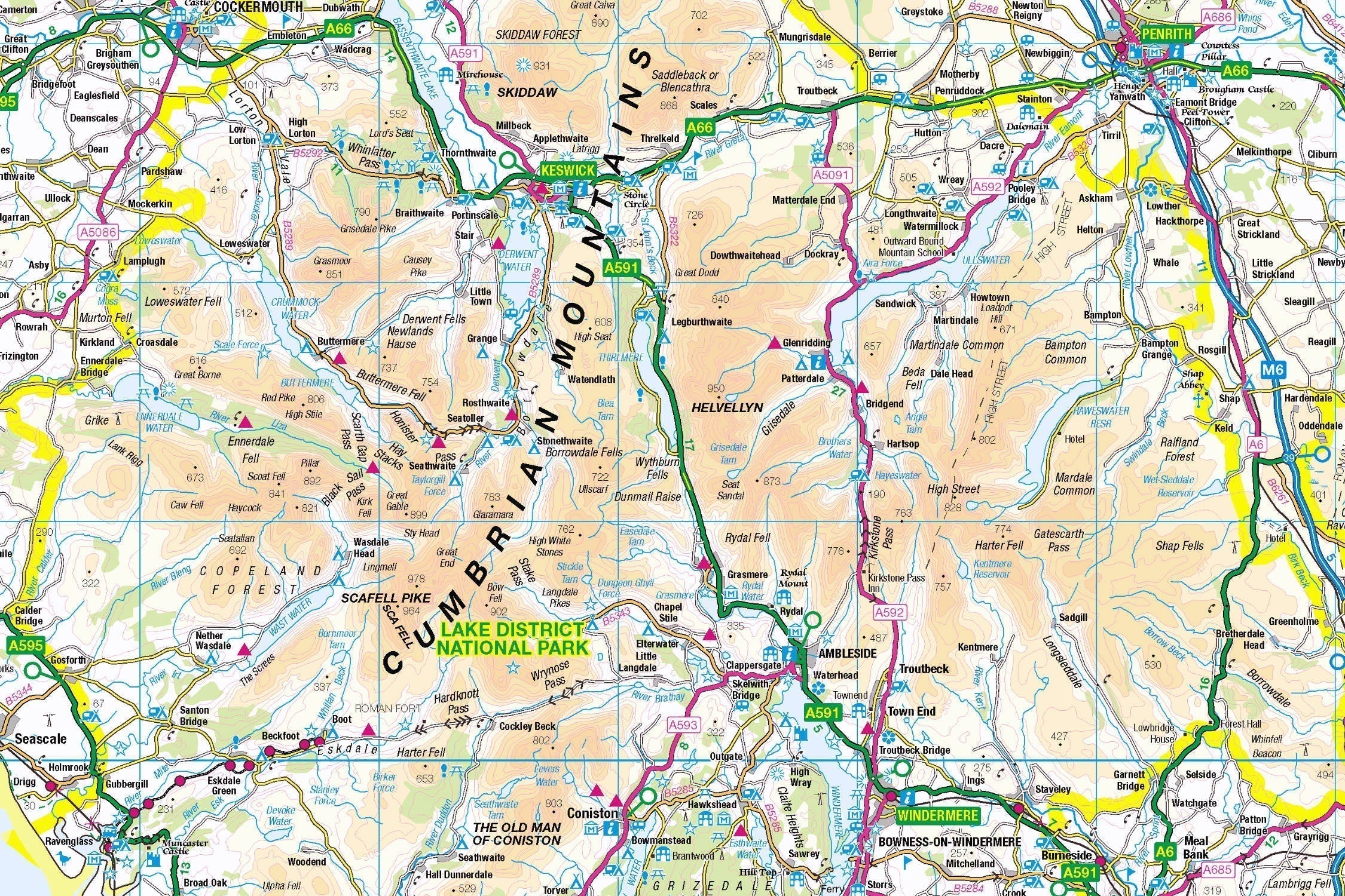
The Lake District Map Jigsaw from Pieceful Maps transforms Ordnance Survey's definitive 1:250,000 scale mapping into a captivating 1000-piece challenge. Measuring 69cm x 48cm when complete, this puzzle showcases England's largest national park with cartographic precision. Created under the Open Government Licence, every road, settlement, and park boundary is reproduced with official accuracy, offering both puzzle enthusiasts and geography lovers a unique way to connect with this legendary landscape.
Why This Scale Works: The 1:250,000 scale provides the perfect regional overview, capturing the Lake District's entirety while clearly displaying:
-
All major towns and villages
-
Road networks from motorways to country lanes
-
Key tourist attractions and landmarks
-
Precise national park boundaries
The Lake District: Mountain Majesty
England's Largest National Park
Covering 2,362 square kilometres of mountainous terrain, the Lake District became a UNESCO World Heritage Site in 2017 for its cultural landscape. This legendary region attracts over 16 million visitors annually, drawn to its glacial ribbon lakes, fell-top perspectives, and literary connections to Wordsworth and Beatrix Potter.
Essential Statistics:
-
Size: 912 square miles (England's largest national park)
-
Peaks: 214 fell tops including Scafell Pike (978m)
-
Lakes: 16 major bodies of water including Windermere
-
Visitors: 16+ million annually
-
UNESCO Status: World Heritage Site since 2017
Navigational Highlights Revealed
As your puzzle takes shape, discover these iconic features:
-
Key Towns: Keswick (northern adventure hub), Ambleside (walking capital), Bowness-on-Windermere (boating centre)
-
Legendary Lakes: Windermere (England's longest), Ullswater (most scenic), Derwentwater (island-studded)
-
Road Networks: A591 (Lakeland's spinal route), Honister Pass (dramatic mountain road)
-
Cultural Icons: Dove Cottage (Wordsworth's home), Hill Top Farm (Beatrix Potter's sanctuary)
The Art of Road Map Puzzling
Strategic Assembly Approach
Road map puzzles offer unique solving opportunities with their clear linear features and colour-coded routes:
-
Boundary First: Connect the national park perimeter using distinctive green border markings
-
Road Network: Follow the orange A-roads and yellow B-roads to create a transport skeleton
-
Water Features: Piece together blue lake outlines and connecting rivers
-
Settlement Clusters: Build market towns then populate surrounding villages
-
Final Details: Add forest areas (dark green) and tourist symbols
Cognitive Benefits:
-
Spatial Reasoning: Understanding how settlements connect via road networks
-
Pattern Recognition: Identifying colour-coded route hierarchies
-
Memory Training: Recalling relative locations of towns and landmarks
-
Stress Reduction: The meditative focus of "route building"
Why Ordnance Survey Road Mapping Excels
Unrivalled Cartographic Clarity
Our puzzles use official 1:250,000 scale data that balances comprehensive coverage with exceptional readability. This regional mapping scale ensures:
-
All national park boundaries are fully visible
-
Every village and town is clearly labelled
-
Road hierarchies are instantly distinguishable by colour
-
Tourist attractions are prominently marked
The Open Government Licence Advantage:
"Contains public sector information licensed under the Open Government Licence - os.uk/opendata/licence"
This official permission allows:
✅ Accurate reproduction of OS road mapping
✅ Commercial product development
✅ Guaranteed data integrity
✅ Legal compliance assurance
Scale Perfection
The 1:250,000 scale (1cm = 2.5km) delivers the ideal balance for national park puzzles:
-
Regional Context: Entire park in single view
-
Settlement Detail: All villages included
-
Practical Use: Perfect for trip planning
-
Puzzle Practicality: Manageable complexity with recognisable features
Pieceful Maps: Craftsmanship Meets Exploration
From Puzzle to Adventure Planning
Completed your masterpiece? It transforms into practical trip-planning artwork:
-
Preserve: Apply puzzle conservation glue
-
Frame: Choose a deep-rebate frame
-
Display: Study, walking club, or travel hub
-
Plan: Mark walking routes directly on glass with dry-wipe pens
Real-World Exploration Tips:
-
Road Trip: Follow the A591 from Windermere to Keswick (35 miles of Lakeland splendour)
-
Hidden Village: Visit Hawkshead for Beatrix Potter connections
-
Viewpoint: Surprise View overlooking Derwentwater
-
When to Visit: May (spring blossoms) or September (autumn colours)
Why This Puzzle?
"The Lake District puzzle turns armchair exploration into geographical mastery. Where else can you trace Wainwright's favourite routes, locate every lakeside village, and plan tomorrow's hike - all without getting your boots muddy?" - Pieceful Maps Designer
The Mindful Mapping Experience
This 1000-piece challenge delivers:
-
Digital Detox: 8-12 hours of screen-free immersion
-
Family Bonding: Collaborative navigation fun
-
Achievement High: Dopamine release upon completion
-
Geographical Mastery: Deep understanding of Lakeland's layout
-
Wall Art Reward: Stunning display piece
Ready to navigate England's mountain kingdom? The Lake District awaits - one piece at a time.
About Pieceful Maps: We transform official Ordnance Survey data into captivating jigsaw experiences celebrating Britain's national parks through mindful puzzling.
Latest Product Reviews

A Proud Kase UK Partner
The use of high quality glass filters for landscape photography is quite simply game changing and will improve your resulting images. I am happy to talk filters and help you get started, start a conversation here
