


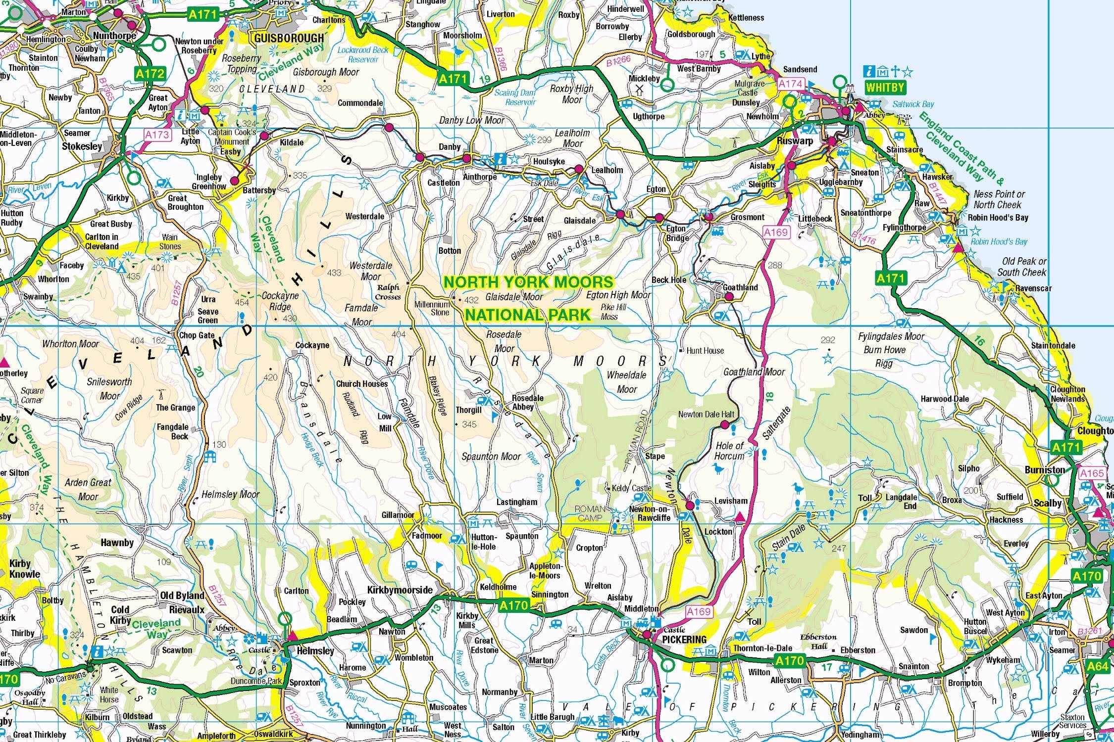
Introducing the North York Moors Map Jigsaw
Pieceful Maps invites you to assemble England's most dramatic coastline-to-moorland landscape with our North York Moors Map Jigsaw. This 1,000-piece puzzle (69cm x 48cm assembled) transforms Ordnance Survey's definitive 1:250,000 roadmap into an immersive journey through purple heathlands, fishing villages, and ancient woodlands. Created under the Open Government Licence, every road, settlement, and heritage site is reproduced with cartographic precision – perfect for explorers and puzzle enthusiasts alike .
Why This Scale Captures the Magic:
-
Complete Park Coverage: 554 square miles from coast to moor
-
Settlement Clarity: Every village from Goathland to Staithes clearly visible
-
Coastal Precision: Unique inclusion of dramatic North Sea coastline
-
Boundary Definition: Distinctive park perimeter for easy orientation
The North York Moors: Coast & Heather Wilderness
A Landscape of Contrasts
Designated in 1952, this national park stretches from Saltburn's cliffs to Pickering's forests, featuring England's largest continuous heather moorland. Its 2019 Dark Sky Reserve status makes it one of Europe's premier stargazing destinations.
Essential North York Moors Data:
| Feature | Detail |
|---|---|
| Size | 554 square miles |
| Unique Claim | Largest heather moorland in England |
| Heritage Sites | 12 historic abbeys & castles |
| Coastline | 26 miles of Heritage Coast |
| Dark Sky Status | International Dark Sky Reserve |
Navigational Treasures
Assemble your puzzle to uncover these iconic features:
-
Coastal Gems: Whitby (Dracula's harbour town), Robin Hood's Bay (smugglers' cove), Staithes (picturesque fishing village)
-
Moorland Hubs: Helmsley (market town gateway), Pickering (North Yorkshire Moors Railway hub), Danby (National Park Centre)
-
Transport Routes: A171 (coast road), A169 (moorland crossing), and the heritage railway line
-
Cultural Icons: Whitby Abbey (Gothic ruins), Goathland Station (Hogsmeade in Harry Potter films)
Mastering Moorland Map Puzzling
Strategic Assembly Guide
This puzzle's unique coast-to-inland transition offers satisfying solving stages:
-
Coastline First: Connect the dramatic North Sea shoreline from Saltburn to Scarborough
-
Road Anchors: Assemble the A171 coast road and A170 southern boundary
-
Heritage Railway: Piece together the iconic North Yorkshire Moors Railway line
-
Moorland Heart: Build the central heather plateau using park boundary cues
-
Settlement Clusters: Connect market towns before filling rural villages
Cognitive Benefits:
-
Spatial Awareness: Visualising how coastal villages relate to inland moors
-
Pattern Recognition: Identifying road hierarchies against moorland backgrounds
-
Memory Exercise: Recalling relative positions of abbey sites and viewpoints
-
Mindful Focus: Achieving calm through "landscape construction"
Ordnance Survey: The Navigator's Choice
Why OS Road Maps Excel
Our puzzles use official 1:250,000 data – ideal for this diverse park:
-
Coastal Detail: Harbours, beaches, and clifftop paths clearly marked
-
Settlement Hierarchy: Distinguishes towns vs villages vs hamlets
-
Tourist Icons: Highlights heritage railways, abbeys, and viewpoints
-
Boundary Accuracy: Exact park perimeter maintained
"Contains public sector information licensed under the Open Government Licence - os.uk/opendata/licence"
Did You Know? The 1:250,000 scale was originally developed for WWII aviation – today it perfectly frames national parks .
The Pieceful Maps Experience
From Puzzle to Real Adventure
Your completed masterpiece becomes practical trip-planning artwork:
-
Preserve: Apply puzzle glue for permanent display
-
Frame: Choose a rustic oak frame to complement moorland tones
-
Plan: Mark walking routes on the glass with dry-wipe pens
-
Explore: Use your spatial knowledge to navigate the park confidently
Top Real-World Experiences:
-
Moorland Crossing: Drive the A169 "Hole of Horcum" route at sunset
-
Coast to Coast: Walk the Cleveland Way from Saltburn to Filey
-
Heritage Journey: Ride the steam train from Pickering to Whitby
-
Stargazing: Join a Dark Sky event at Danby Observatory
Why This Puzzle Captures Hearts
"The North York Moors puzzle lets you hold an entire universe of contrasts – where else can you trace smuggling coves at lunchtime, locate abbey ruins by teatime, and spot your stargazing spot before bedtime?" – Pieceful Maps Designer
The Mindful Mapping Journey
This 1,000-piece challenge delivers:
-
Digital Detox: 8-12 hours of screen-free immersion
-
Family Bonding: Collaborative coastal-to-moorland assembly
-
Skill Development: Map literacy and spatial awareness
-
Achievement High: Triumph of completing England's heather heartland
-
Wall Art Reward: Striking conversation piece for your home
Ready to navigate England's most colourful wilderness? The North York Moors await – one piece at a time.
About Pieceful Maps: We transform official Ordnance Survey data into captivating jigsaws celebrating Britain’s national parks.
Latest Product Reviews

A Proud Kase UK Partner
The use of high quality glass filters for landscape photography is quite simply game changing and will improve your resulting images. I am happy to talk filters and help you get started, start a conversation here
