


Explore the South Downs: Your Chalk Landscape Jigsaw Adventure
Piece Together England's Iconic White Cliffs and Rolling Hills
Key Highlights
-
UNESCO Status: England's newest national park (2009) with World Heritage chalk cliffs
-
Precision OS Mapping: 1:250,000 scale capturing all villages, roads & boundaries
-
1,000-Piece Challenge: 69cm x 48cm completed size
-
Open Government Licence: Authentic OS data reproduction
-
Mindful Puzzling: Combines cultural heritage with serene assembly
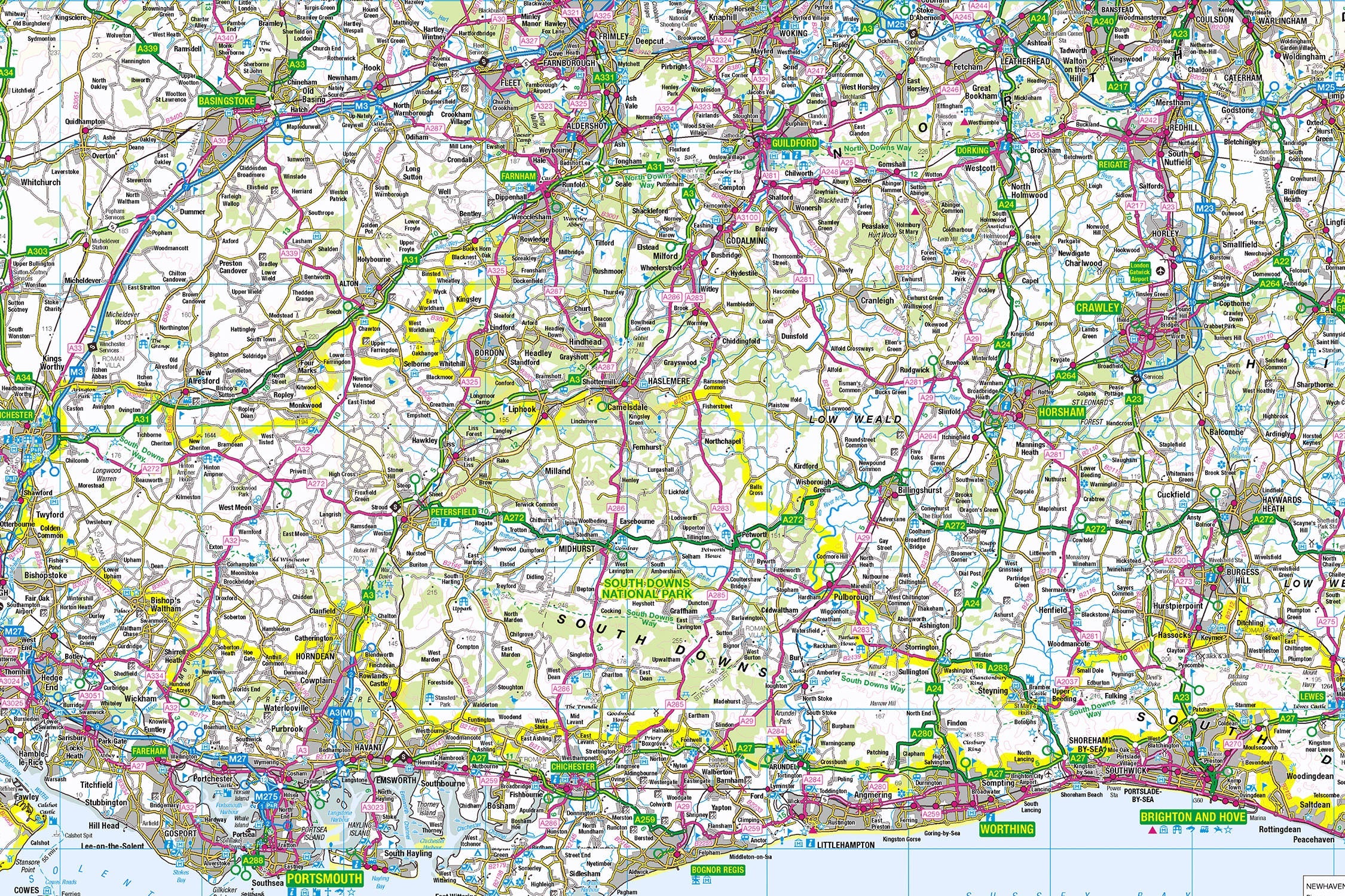
Introducing the South Downs Map Jigsaw
Pieceful Maps invites you to wander through England's sunlit chalklands with our South Downs Map Jigsaw. This 1,000-piece puzzle (69cm x 48cm assembled) transforms Ordnance Survey's 1:250,000 roadmap into a captivating journey from Winchester's cathedral city to the Seven Sisters' dramatic cliffs. Created under the Open Government Licence, every ancient pathway, vineyard, and village is reproduced with cartographic precision – offering history lovers and puzzle enthusiasts a taste of quintessential southern England.
Why This Scale Captures the Essence:
-
Complete Park Coverage: 628 square miles from Hampshire to East Sussex
-
Settlement Clarity: All villages from Alfriston to Midhurst clearly visible
-
Ancient Routes: South Downs Way trail distinctly marked
-
Coastal Precision: Iconic chalk cliffs perfectly framed
The South Downs: England's Sunny Crest
Chalk and Culture
Designated in 2009 as Britain's newest national park, this landscape protects 85 million years of geological history alongside literary connections to Jane Austen and Kipling. Its UNESCO World Heritage status recognises globally significant chalk formations.
Essential Downs Data:
| Feature | Detail |
|---|---|
| Geological Marvel | 85-million-year-old chalk bedrock |
| Longest Trail | South Downs Way (100 miles) |
| Iconic Landmark | Seven Sisters cliffs (280ft) |
| Literary Links | Jane Austen's Hampshire settings |
| Vineyards | 50+ award-winning estates |
Navigational Treasures
Assemble your puzzle to uncover these iconic features:
-
Cathedral Cities: Winchester (ancient capital), Chichester (Roman grid streets)
-
Iconic Landscapes: Beachy Head (highest chalk sea cliff), Devil's Dyke (deepest dry valley)
-
Cultural Icons: Arundel Castle, Jane Austen's House, Glyndebourne Opera
-
Charming Villages: Alfriston (clergy house), Amberley (thatched cottages), Selborne (Gilbert White's village)
Mastering Chalkland Map Puzzling
Strategic Assembly Approach
This puzzle's linear geography offers logical solving stages:
-
Downs Spine First: Piece together the South Downs Way trail symbols
-
Historic Anchors: Build Winchester and Chichester cathedral cities
-
Coastal Crescendo: Connect the Seven Sisters cliffs to Beachy Head
-
River Valleys: Follow the Arun, Adur, and Cuckmere rivers
-
Village Clusters: Complete vineyard-dotted settlements like Ditchling
Cognitive Benefits:
-
Spatial Reasoning: Visualising how dry valleys connect to coastal cliffs
-
Pattern Recognition: Identifying ancient trackways vs modern roads
-
Memory Exercise: Recalling relative positions of literary landmarks
-
Mindful Focus: Achieving calm through "landscape sculpting"
Ordnance Survey: The Downlander's Companion
Why OS Maps Excel for Chalklands
Our puzzles use official 1:250,000 data – perfect for this historic landscape:
-
Trail Precision: South Downs Way clearly marked
-
Geological Features: Highlights chalk escarpments and dry valleys
-
Heritage Symbols: Castles, historic houses, and viewpoints
-
Practical Detail: Shows vineyard locations and farmers' markets
"Contains public sector information licensed under the Open Government Licence - os.uk/opendata/licence"
Historical Note: The South Downs Way appears on OS maps following the same routes used by Bronze Age traders 5,000 years ago.
The Pieceful Maps Experience
From Puzzle to Downland Adventure
Your completed masterpiece becomes practical exploration artwork:
-
Preserve: Apply puzzle glue for permanent display
-
Frame: Choose a white-washed frame complementing chalk landscapes
-
Plan: Mark walking/wine-tasting routes on the glass
-
Explore: Use your spatial knowledge to discover hidden valleys
Top Real-World Experiences:
-
Cliff Walk: Seven Sisters from Seaford Head to Birling Gap
-
Literary Pilgrimage: Jane Austen's Chawton cottage and Winchester grave
-
Vineyard Cycle: Trail between Hambledon, Nyetimber, and Rathfinny estates
-
Sunset View: Devil's Dyke vista over Weald countryside
Why Puzzlers Love This Chalkland Challenge
"The South Downs puzzle offers a journey through England's sunny soul. Where else can you 'walk' Bronze Age tracks before breakfast, picnic atop white cliffs at lunch, and attend an opera in the Downs by evening – all without leaving your table?" – Pieceful Maps Designer
The Mindful Mapping Journey
This 1,000-piece challenge delivers:
-
Digital Detox: 8-12 hours of screen-free tranquillity
-
Family Bonding: Collaborative landscape assembly
-
Skill Development: Map literacy and cultural geography
-
Achievement High: Triumph of completing England's sunny crest
-
Wall Art Reward: Breathtaking display piece for your home
Ready to wander through England's sunlit chalk kingdom? The South Downs await – one piece at a time.
About Pieceful Maps: We transform official Ordnance Survey data into captivating jigsaws celebrating Britain’s national parks.
Latest Product Reviews

A Proud Kase UK Partner
The use of high quality glass filters for landscape photography is quite simply game changing and will improve your resulting images. I am happy to talk filters and help you get started, start a conversation here
