


Discover the New Forest: Your Ancient Woodland Jigsaw Adventure
Piece Together England's Pastoral Paradise
Key Highlights
-
Royal Heritage: William the Conqueror's former hunting forest
-
Precision OS Mapping: 1:250,000 scale capturing all villages, roads & boundaries
-
1,000-Piece Challenge: 69cm x 48cm completed size
-
Open Government Licence: Authentic OS data reproduction
-
Mindful Puzzling: Combines natural history with tranquil assembly
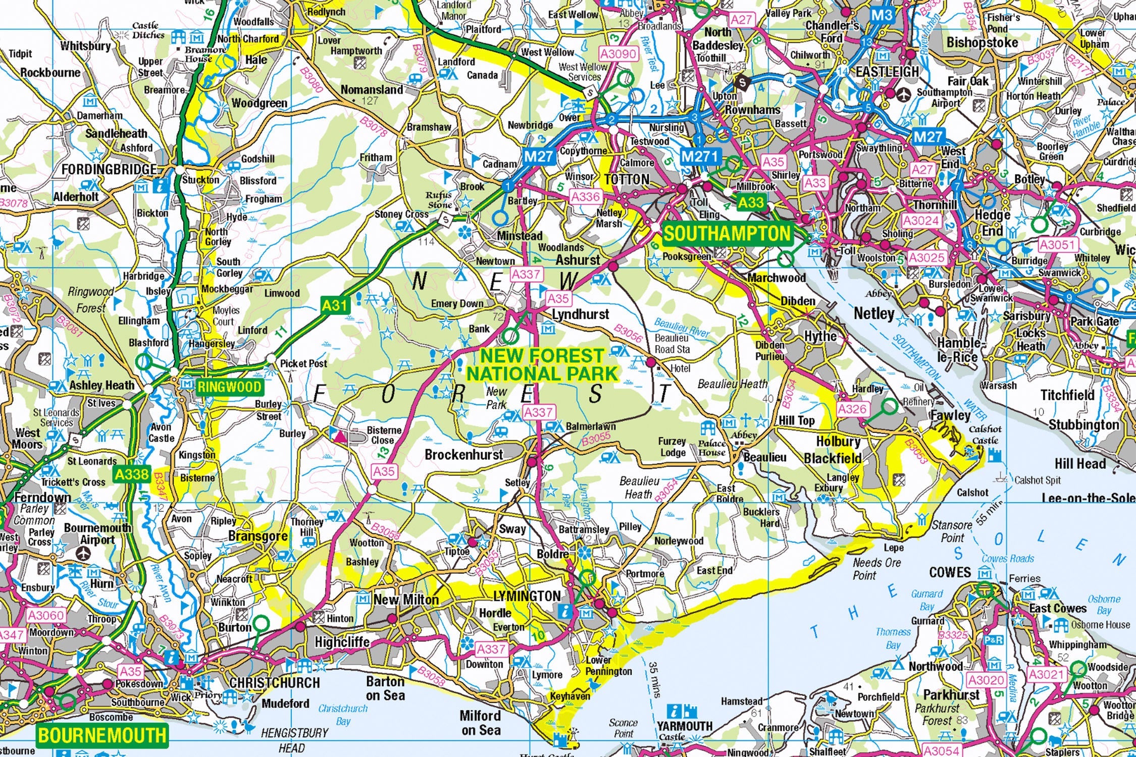
Introducing the New Forest Map Jigsaw
Pieceful Maps invites you to wander through England's living medieval landscape with our New Forest Map Jigsaw. This 1,000-piece puzzle (69cm x 48cm assembled) transforms Ordnance Survey's 1:250,000 roadmap into a serene journey through ancient woodlands, heather-clad heaths, and picturesque villages. Created under the Open Government Licence, every road, settlement, and park boundary is reproduced with cartographic precision – offering nature lovers and puzzle enthusiasts a peaceful escape into Britain's best-preserved medieval hunting forest.
Why This Scale Captures the Essence:
-
Complete Park Coverage: 219 square miles of protected landscape
-
Settlement Clarity: All villages from Lyndhurst to Burley clearly visible
-
Ancient Rights: Commoner's roads and grazing areas distinctly marked
-
Boundary Definition: Distinctive national park perimeter
The New Forest: William the Conqueror's Legacy
A Working Wilderness
Designated in 2005, this unique park protects England's highest concentration of ancient trees alongside a thriving medieval commoning system. Unlike other national parks, its landscape is shaped by free-roaming ponies, cattle, and pigs that maintain the ecosystem.
Essential Forest Data:
| Feature | Detail |
|---|---|
| Ancient Trees | 1,000+ veteran oaks & beeches |
| Free-Roaming Animals | 5,000+ ponies, cattle & pigs |
| Villages | 40+ picturesque settlements |
| Protected Status | National Park since 2005 |
| Unique Rights | Commoners' grazing rights since 1079 |
Navigational Treasures
Assemble your puzzle to uncover these iconic features:
-
Forest Capitals: Lyndhurst (official "capital"), Brockenhurst (pony-filled village), Beaulieu (abbey and motor museum)
-
Ancient Routes: A35 (northern boundary), B3056 (forest spine road), Rhinefield Ornamental Drive
-
Cultural Icons: Beaulieu Palace House, Rufus Stone (William II death site), Buckler's Hard (historic shipbuilding village)
-
Natural Wonders: Knightwood Oak (500-year-old giant), Bolderwood Deer Sanctuary, Hatchet Pond (largest forest waterbody)
Mastering Woodland Map Puzzling
Strategic Assembly Approach
This puzzle's radial village pattern offers satisfying solving stages:
-
Villages First: Build Lyndhurst, Brockenhurst, and Ringwood as anchors
-
Road Network: Connect the A35, A337, and B3056 as structural spines
-
Boundary Definition: Piece together the distinctive park perimeter
-
Forest Features: Add key landmarks like Beaulieu and deer sanctuaries
-
Scattered Settlements: Complete isolated hamlets connected by forest tracks
Cognitive Benefits:
-
Spatial Reasoning: Visualising how villages connect through woodland
-
Pattern Recognition: Identifying road hierarchies against green spaces
-
Memory Exercise: Recalling relative positions of ancient trees
-
Mindful Focus: Achieving calm through "woodland construction"
Ordnance Survey: The Forest Explorer's Companion
Why OS Maps Excel for Woodlands
Our puzzles use official 1:250,000 data – perfect for this unique park:
-
Access Clarity: Rights-of-way and permissive paths marked
-
Settlement Hierarchy: Distinguishes villages vs hamlets
-
Heritage Symbols: Highlights historic sites and viewpoints
-
Practical Detail: Shows car parks and visitor centres
"Contains public sector information licensed under the Open Government Licence - os.uk/opendata/licence"
Historical Note: The New Forest appears on OS maps with the same boundary established by William the Conqueror in 1079 – Britain's oldest protected landscape.
The Pieceful Maps Experience
From Puzzle to Forest Adventure
Your completed masterpiece becomes practical exploration artwork:
-
Preserve: Apply puzzle glue for permanent display
-
Frame: Choose an oak-effect frame complementing woodland tones
-
Plan: Mark walking/cycling routes on the glass
-
Explore: Use your spatial knowledge to discover hidden glades
Top Real-World Experiences:
-
Pony Safari: Walk from Brockenhurst station spotting free-roaming herds
-
Tree Pilgrimage: Visit the 500-year-old Knightwood Oak
-
Historic Walk: Rufus Stone to Beaulieu via woodland paths
-
Waterfront Dining: The Pig Hotel's forest-to-fork cuisine
Why Puzzlers Love This Forest Journey
"The New Forest puzzle offers the ultimate woodland escape. Where else can you 'wander' through ancient oaks before breakfast, picnic by a deer sanctuary at lunch, and explore a shipbuilding village by teatime – all without leaving your living room?" – Pieceful Maps Designer
The Mindful Mapping Journey
This 1,000-piece challenge delivers:
-
Digital Detox: 6-8 hours of screen-free tranquillity
-
Family Bonding: Collaborative woodland assembly
-
Skill Development: Map literacy and spatial awareness
-
Achievement High: Triumph of completing England's ancient forest
-
Wall Art Reward: Serene display piece for nature lovers
Ready to wander through England's living medieval landscape? The New Forest awaits – one piece at a time.
About Pieceful Maps: We transform official Ordnance Survey data into captivating jigsaws celebrating Britain’s national parks.
Latest Product Reviews

A Proud Kase UK Partner
The use of high quality glass filters for landscape photography is quite simply game changing and will improve your resulting images. I am happy to talk filters and help you get started, start a conversation here
