


Discover Northumberland: Your Dark Sky & Roman Frontier Jigsaw Adventure
Piece Together England's Wild Borderlands
Key Highlights
-
Dark Sky Sanctuary: Europe's largest protected night sky area
-
Roman Heritage: Home to Hadrian's Wall UNESCO World Heritage Site
-
Precision OS Mapping: 1:250,000 scale capturing all towns, roads & boundaries
-
1,000-Piece Challenge: 69cm x 48cm completed size
-
Open Government Licence: Authentic OS data reproduction
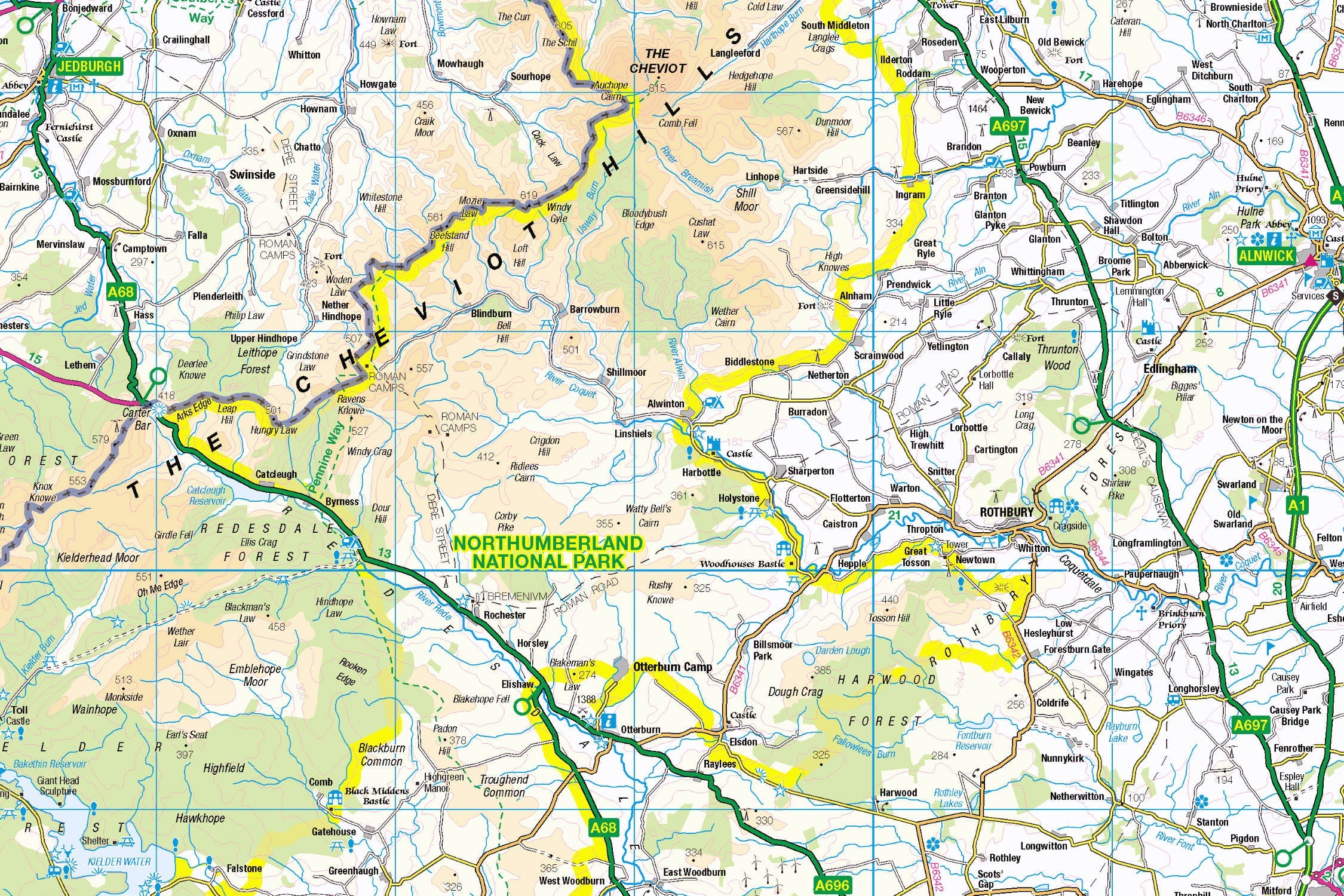
Northumberland Map Jigsaw
Pieceful Maps invites you to explore England's wild frontier with our Northumberland Map Jigsaw. This 1,000-piece puzzle (69cm x 48cm assembled) transforms Ordnance Survey's 1:250,000 roadmap into a captivating journey through ancient battlefields, star-filled skies, and the mightiest Roman monument in Britain. Created under the Open Government License, every castle, settlement, and park boundary is reproduced with cartographic precision – perfect for history buffs and stargazers seeking a mindful challenge.
Why This Scale Fits the Frontier:
-
Complete Park Coverage: 405 square miles from Scottish borders to Roman walls
-
Settlement Clarity: All villages from Bellingham to Wooler clearly visible
-
Historic Precision: Hadrian's Wall path distinctly marked
-
Dark Sky Focus: Remote wilderness areas perfectly framed
Northumberland: Land of Dark Skies and Ancient Stones
England's Last Wilderness
Designated in 1956, this northernmost national park protects England's cleanest rivers, least light-polluted skies, and the iconic central section of Hadrian's Wall. With just 2,000 residents, it's England's least populated national park – a true wilderness escape .
Essential Borderlands Data:
| Feature | Detail |
|---|---|
| Dark Sky Status | Gold Tier International Dark Sky Park |
| Roman Heritage | 35-mile section of Hadrian's Wall |
| Highest Point | The Cheviot (815m) |
| Population | 2,000 residents (lowest density) |
| Castles | 70+ along the border |
Navigational Treasures
Assemble your puzzle to uncover these iconic features:
-
Roman Icons: Housesteads Fort (best-preserved Roman fort), Sycamore Gap (Robin Hood tree site), Steel Rigg (dramatic wall section)
-
Border Towns: Hexham (ancient market town), Wooler (Cheviot Hills gateway), Bellingham (dark sky village)
-
Historic Routes: B6318 (Military Road), A68 (Edinburgh corridor), Pennine Way trail
-
Cultural Landmarks: Kielder Observatory, Cragside Estate (first hydro-powered house), Lindisfarne Castle (tidal island fortress)
Mastering Borderlands Map Puzzling
Strategic Assembly Approach
This puzzle's linear Roman wall offers a unique solving spine:
-
Wall First: Piece together Hadrian's Wall as your central backbone
-
Road Anchors: Connect the A68 and B6318 as transport arteries
-
Dark Sky Zones: Build the remote western wilderness areas
-
Settlement Clusters: Complete Hexham, Bellingham, and Wooler
-
Border Definition: Use the distinctive park boundary to frame your progress
Cognitive Benefits:
-
Historical Contextualization: Visualising Roman frontier systems
-
Spatial Reasoning: Understanding relationship between forts and terrain
-
Pattern Recognition: Identifying settlement patterns along the wall
-
Mindful Focus: Achieving calm through "frontier construction"
Ordnance Survey: The Historian's Compass
Why OS Maps Excel for Borderlands
Our puzzles use official 1:250,000 data – perfect for this historic landscape:
-
Heritage Clarity: Roman wall and forts prominently marked
-
Settlement Hierarchy: Distinguishes market towns from hamlets
-
Dark Sky Zones: Shows key stargazing locations
-
Practical Detail: Highlights viewpoints and visitor centres
"Contains public sector information licensed under the Open Government Licence - os.uk/opendata/licence"
Historical Note: OS first mapped this region for military purposes during Jacobite rebellions – the same routes used by Roman soldiers centuries earlier.
The Pieceful Maps Experience
From Puzzle to Frontier Adventure
Your completed masterpiece becomes practical exploration artwork:
-
Preserve: Apply puzzle glue for permanent display
-
Frame: Choose a stone-effect frame honouring Roman walls
-
Plan: Mark walking/stargazing spots on the glass
-
Explore: Use your spatial knowledge to navigate the borderlands
Top Real-World Experiences:
-
Wall Walk: Housesteads to Steel Rigg (best Roman vistas)
-
Stargazing: Kielder Observatory Milky Way sessions
-
Border Crossing: Walk from England to Scotland via Cheviot Hills
-
Castle Trail: Visit Warkworth, Dunstanburgh, and Bamburgh castle
Why Puzzlers Love This Frontier Challenge
"The Northumberland puzzle lets you patrol Hadrian's Wall before breakfast, map medieval castles by lunch, and navigate by the Milky Way after dark – all while warm and dry in your fortress home!" – Pieceful Maps Designer
The Mindful Mapping Journey
This 1,000-piece challenge delivers:
-
Digital Detox: 8-12 hours of screen-free immersion
-
Historical Connection: Tangible link to Roman Britain
-
Skill Development: Map literacy and spatial strategy
-
Achievement High: Triumph of completing England's wild frontier
-
Wall Art Reward: Dramatic conversation piece for your home
Ready to explore England's last wilderness? Northumberland awaits – one piece at a time.
About Pieceful Maps: We transform official Ordnance Survey data into captivating jigsaws celebrating Britain’s national parks.
Latest Product Reviews

A Proud Kase UK Partner
The use of high quality glass filters for landscape photography is quite simply game changing and will improve your resulting images. I am happy to talk filters and help you get started, start a conversation here
