


Discover the Pembrokeshire Coast: Your OS Coastal Path Jigsaw Adventure
Piece Together Britain's Only Coastal National Park
Key Highlights
-
Unique Status: UK's only fully coastal national park
-
Precision OS Mapping: 1:250,000 scale capturing all coastal paths & settlements
-
1,000-Piece Challenge: 69cm x 48cm completed size
-
Open Government Licence: Authentic OS data reproduction
-
Mindful Puzzling: Combines coastal geography with relaxing assembly
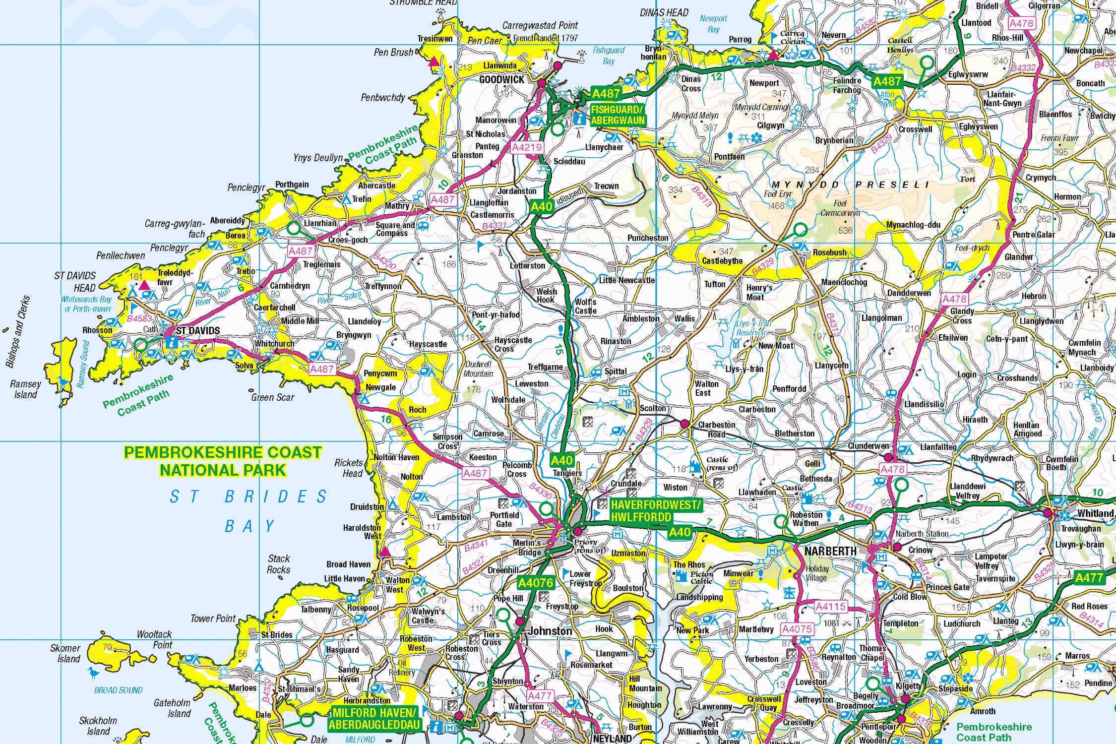
Introducing the Pembrokeshire Coast Map Jigsaw
Pieceful Maps invites you to journey along Wales' wild western edge with our Pembrokeshire Coast Map Jigsaw. This 1,000-piece puzzle (69cm x 48cm assembled) transforms Ordnance Survey's definitive 1:250,000 roadmap into a captivating voyage past golden beaches, dramatic cliffs, and historic harbour towns. Created under the Open Government Licence, every coastal path, settlement, and heritage site is reproduced with cartographic precision – perfect for armchair explorers and puzzle lovers seeking a coastal escape.
Why This Scale Captures the Coastline:
-
Complete Park Coverage: 240 miles of shoreline in one view
-
Island Visibility: Skomer, Ramsey, and Caldey clearly marked
-
Settlement Clarity: Every village from Tenby to St Davids
-
Path Precision: National Trail route distinctly shown
Pembrokeshire Coast: Where Land Meets Sea
Britain's Coastal Crown Jewel
Designated in 1952, this unique park protects 629 km² of pristine coastline, offshore islands, and hidden coves. Its 186-mile Coast Path became the world's first national trail in 2012, attracting 1 million annual visitors to its blue-flag beaches and wildlife-rich waters.
Essential Coastal Data:
| Feature | Detail |
|---|---|
| Coast Path | 186 miles (world's first national trail) |
| Beaches | 58 awarded Blue Flag status |
| Islands | 7 major wildlife sanctuaries |
| Marine Life | Dolphins, seals & puffin colonies |
| Unique Geology | 600-million-year-old rock formations |
Navigational Treasures
Assemble your puzzle to uncover these iconic features:
-
Historic Harbours: Tenby (colourful medieval walls), Fishguard (last invasion of Britain site), Solva (picturesque inlet)
-
Island Jewels: Skomer (puffin paradise), Caldey (monastic island), Ramsey (seal colony haven)
-
Coastal Icons: St Davids Cathedral (Britain's smallest city), Green Bridge sea arch, Barafundle Bay (world-class beach)
-
Heritage Routes: A487 coastal road, Brunel's railway line, Celtic pilgrimage trails
Mastering Coastal Map Puzzling
Strategic Assembly Approach
Coastal puzzles offer unique solving dynamics with their looping paths and intricate shorelines:
-
Coastline First: Connect the distinctive jagged perimeter
-
Path Anchors: Piece together the Pembrokeshire Coast Path symbols
-
Island Clusters: Build Skomer, Ramsey, and Caldey
-
Harbour Hubs: Assemble Tenby, St Davids, and Milford Haven
-
Inland Links: Connect roads and settlements like Haverfordwest
Cognitive Benefits:
-
Spatial Awareness: Visualising how headlands connect to bays
-
Pattern Recognition: Identifying coastal vs inland symbols
-
Memory Exercise: Recalling relative positions of islands
-
Mindful Focus: Achieving calm through "coastal construction"
Ordnance Survey: The Coastal Navigator's Essential
Why OS Maps Excel for Shorelines
Our puzzles use official 1:250,000 data – perfect for coastal navigation:
-
Path Precision: National Trail route clearly marked
-
Tidal Features: Highlights beaches, cliffs, and access points
-
Heritage Symbols: Castles, lighthouses, and ancient sites
-
Practical Detail: Shows parking, viewpoints, and ferry routes
"Contains public sector information licensed under the Open Government Licence - os.uk/opendata/licence"
Historical Note: OS first mapped this coast during the Napoleonic Wars to identify invasion points – today it guides peaceful exploration.
The Pieceful Maps Experience
From Puzzle to Coastal Adventure
Your completed masterpiece becomes practical trip-planning artwork:
-
Preserve: Apply puzzle glue for permanent display
-
Frame: Choose a driftwood-effect frame
-
Plan: Mark kayak routes on the glass with dry-wipe pens
-
Explore: Use your spatial knowledge to navigate the coast
Top Real-World Experiences:
-
Coast Path Section: Walk St Davids Head to Whitesands Bay (seal-spotting guaranteed)
-
Island Adventure: Take the Skomer Island boat trip at dawn
-
Beach Hopping: Discover Barafundle Bay via Bosherston Lily Ponds
-
Cultural Pilgrimage: St Davids Cathedral and Celtic crosses
Why Puzzlers Love This Coastal Challenge
"The Pembrokeshire puzzle turns armchair navigation into a seaside holiday. Where else can you explore tidal islands at breakfast, trace coastal paths by lunch, and find your perfect sunset beach by teatime – all without sand in your socks?" – Pieceful Maps Designer
The Mindful Mapping Journey
This 1,000-piece challenge delivers:
-
Digital Detox: 8-12 hours of screen-free tranquillity
-
Family Bonding: Collaborative coastal assembly
-
Skill Development: Coastal navigation and map literacy
-
Achievement High: Triumph of completing Wales' wild edge
-
Wall Art Reward: Breathtaking display piece for your home
Ready to navigate Britain's coastal masterpiece? The Pembrokeshire Coast awaits – one piece at a time.
About Pieceful Maps: We transform official Ordnance Survey data into captivating jigsaws celebrating Britain’s national parks.
Latest Product Reviews

A Proud Kase UK Partner
The use of high quality glass filters for landscape photography is quite simply game changing and will improve your resulting images. I am happy to talk filters and help you get started, start a conversation here
