


Explore the Brecon Beacons: Your OS Wild Moorland Jigsaw Adventure
Piece Together Waterfall Country and Dark Sky Wonders
Key Highlights
-
Diverse Landscape: From South Wales' highest peak to Europe's largest waterfall area
-
Precision OS Mapping: 1:250,000 scale capturing towns, roads & park boundaries
-
1,000-Piece Challenge: 69cm x 48cm completed size
-
Open Government Licence: Authentic OS data reproduction
-
Mindful Puzzling: Combines geography mastery with relaxing assembly
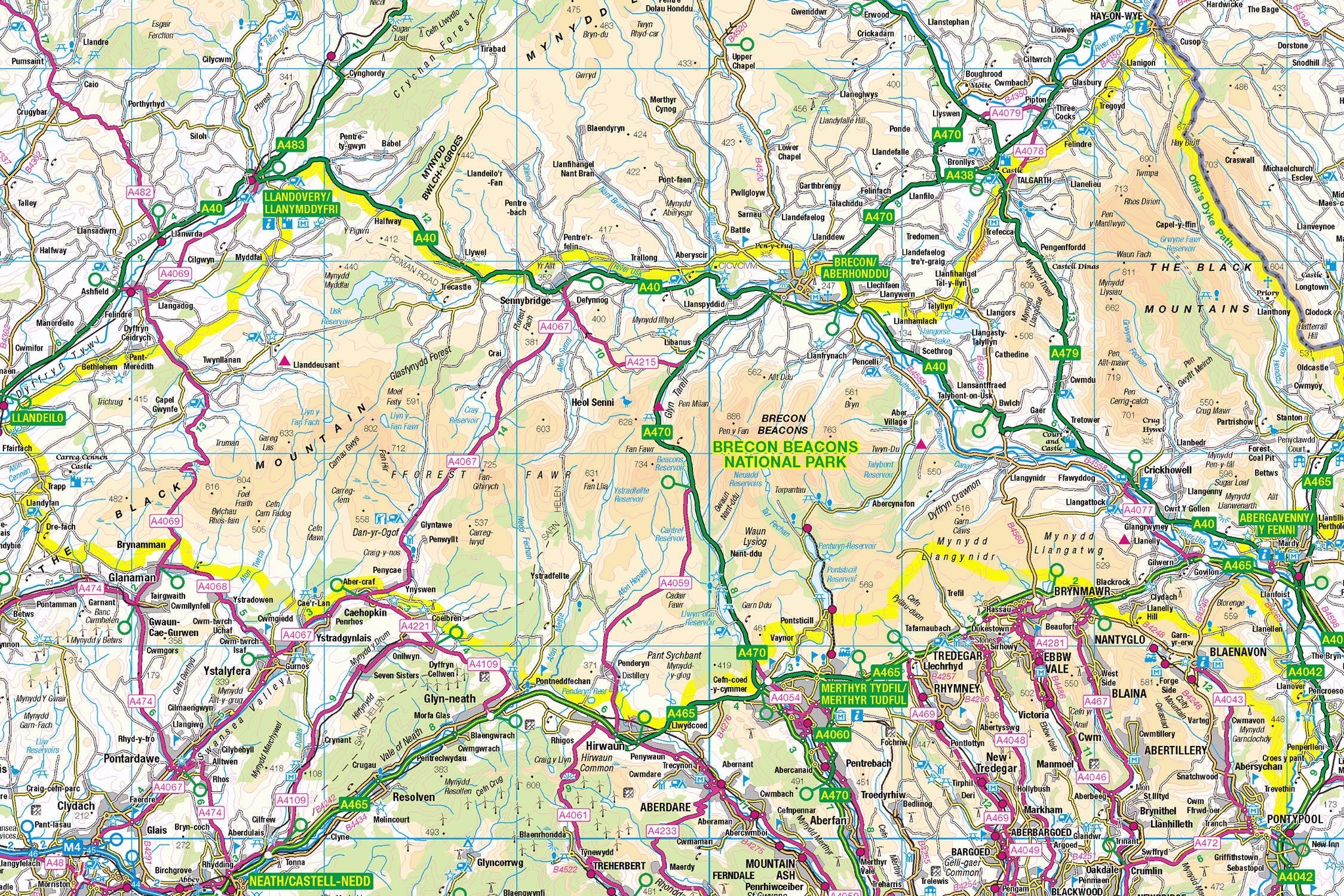
Introducing the Brecon Beacons Map Jigsaw
Pieceful Maps invites you to discover Wales' wild south with our Brecon Beacons Map Jigsaw. This 1,000-piece puzzle (69cm x 48cm assembled) transforms Ordnance Survey's definitive 1:250,000 roadmap into an immersive journey through glacial valleys, market towns, and Europe's most spectacular waterfall country. Created under the Open Government Licence, every road, settlement, and heritage site is reproduced with cartographic precision – perfect for explorers seeking a mindful challenge.
Why This Scale Captures the Essence:
-
Complete Park Coverage: 519 square miles from Black Mountains to Waterfall Country
-
Settlement Clarity: All towns from Abergavenny to Llandovery clearly visible
-
Road Network Focus: Colour-coded routes through mountain passes
-
Boundary Definition: Distinctive national park perimeter
The Brecon Beacons: Waterfall Wonderland
Land of Contrasts
Established in 1957 (and recently renamed Bannau Brycheiniog), this national park protects four distinct regions: the Black Mountains, Central Beacons, Waterfall Country, and Black Mountain. Its 2023 rebrand honours Welsh heritage while preserving its 520 million-year-old geology.
Essential Beacons Data:
| Feature | Detail |
|---|---|
| Highest Peak | Pen y Fan (886m) |
| Waterfalls | 20+ in 10km stretch (European record) |
| Dark Sky Status | International Dark Sky Reserve |
| Geology | Old Red Sandstone formations |
| Annual Visitors | 4.4 million |
Navigational Treasures
Assemble your puzzle to uncover these iconic features:
-
Market Towns: Brecon (historic cathedral town), Crickhowell (gateway to Black Mountains), Hay-on-Wye (world-famous book town)
-
Legendary Routes: A470 (spine of Wales), A4069 (dramatic mountain road), Gospel Pass (highest road in Wales)
-
Cultural Icons: Carreg Cennen Castle (clifftop fortress), Brecon Cathedral, Tretower Court (medieval manor)
-
Natural Wonders: Sgwd yr Eira (waterfall walk behind curtain), Llangorse Lake (largest natural lake in South Wales)
Mastering Moorland Map Puzzling
Strategic Assembly Approach
This puzzle's distinct regions offer logical solving stages:
-
Peaks First: Start with Pen y Fan, Corn Du, and Cribyn summit symbols
-
Road Anchors: Connect the A470 and A40 as transport spines
-
Valley Network: Piece together the Usk, Wye, and Tawe river valleys
-
Town Clusters: Build Brecon, Abergavenny, and Hay-on-Wye
-
Boundary Completion: Use the park perimeter to frame your progress
Cognitive Benefits:
-
Spatial Reasoning: Visualising how valleys connect mountains to lowlands
-
Pattern Recognition: Identifying road hierarchies against moorland
-
Memory Exercise: Recalling waterfall positions in Waterfall Country
-
Mindful Focus: Achieving calm through "landscape construction"
Ordnance Survey: The Hillwalker's Companion
Why OS Maps Excel for Moorlands
Our puzzles use official 1:250,000 data – ideal for this diverse park:
-
Pass Identification: Critical mountain routes clearly marked
-
Settlement Hierarchy: Distinguishes towns vs villages
-
Heritage Symbols: Highlights castles, abbeys, and viewpoints
-
Practical Detail: Shows parking areas and visitor centres
"Contains public sector information licensed under the Open Government Licence - os.uk/opendata/licence"
Historical Note: The Beacons' name comes from ancient signal fires lit on peaks to warn of invaders – a tradition mapped on modern OS symbols.
The Pieceful Maps Experience
From Puzzle to Real Adventure
Your completed masterpiece becomes practical expedition artwork:
-
Preserve: Apply puzzle glue for permanent display
-
Frame: Choose a deep wooden frame to complement moorland tones
-
Plan: Mark walking routes on the glass with dry-wipe pens
-
Explore: Use your spatial knowledge to tackle iconic trails
Top Real-World Experiences:
-
Peak Challenge: Hike the Horseshoe Ridge (Pen y Fan, Corn Du, Cribyn)
-
Waterfall Walk: Trail of the Four Waterfalls near Ystradfellte
-
Dark Sky Experience: Stargaze at Usk Reservoir (Milky Way visible)
-
Book Lover's Pilgrimage: Hay-on-Wye literary festival (May)
Why Puzzlers Love This Moorland Challenge
"The Brecon Beacons puzzle turns armchair exploration into geographical poetry. Where else can you summit Pen y Fan before breakfast, trace the River Usk by lunch, and browse Hay's bookshops by teatime – all while staying dry?" – Pieceful Maps Designer
The Mindful Mapping Journey
This 1,000-piece challenge delivers:
-
Digital Detox: 8-12 hours of screen-free immersion
-
Family Bonding: Collaborative peak-and-waterfall assembly
-
Skill Development: Map literacy and terrain analysis
-
Achievement High: Triumph of completing Wales' wild south
-
Wall Art Reward: Striking display piece for your home
Ready to discover Wales' waterfall kingdom? The Brecon Beacons await – one piece at a time.
About Pieceful Maps: We transform official Ordnance Survey data into captivating jigsaws celebrating Britain’s national parks.
Latest Product Reviews

A Proud Kase UK Partner
The use of high quality glass filters for landscape photography is quite simply game changing and will improve your resulting images. I am happy to talk filters and help you get started, start a conversation here
