


Unlock the Peak District: Your OS Map Jigsaw Adventure
Piece Together Britain's First National Park - Where the Landscape Revolution Began
Key Highlights
-
Birthplace of National Parks: UK's first designated national park (1951)
-
Precision OS Road Mapping: 1:250,000 scale capturing all towns, roads & boundaries
-
1,000-Piece Challenge: 69cm x 48cm completed size
-
Open Government Licence: Authentic OS data reproduction
-
Mindful Exploration: Combines geographical education with satisfying puzzling
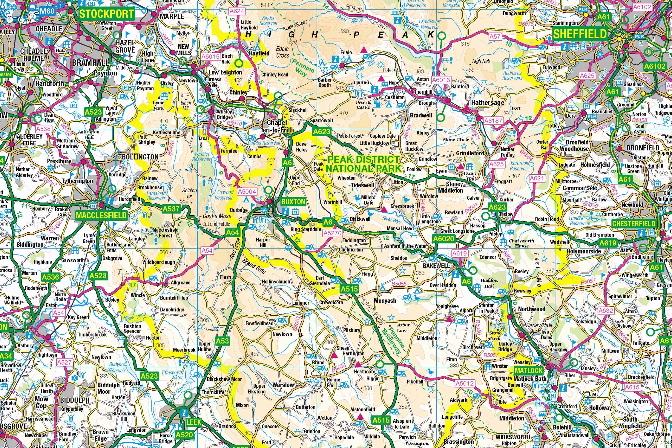
Peak District Map Jigsaw
Pieceful Maps invites you to assemble Britain's conservation crown jewel with our Peak District Map Jigsaw. This 1,000-piece puzzle (69cm x 48cm assembled) transforms Ordnance Survey's definitive 1:250,000 road map into a captivating journey through historic market towns, limestone dales, and the precise boundaries of the park that started a global movement. Created under the Open Government Licence, every road, settlement, and landmark is reproduced with cartographic precision – offering puzzle enthusiasts and geography lovers alike a meaningful connection to Britain's walking paradise.
Why This Scale Captures the Essence:
-
Complete Park Coverage: 555 square miles of protected landscape in one view
-
Settlement Clarity: All 60+ towns and villages clearly labelled
-
Road Network Focus: Colour-coded routes simplify navigation and assembly
-
Boundary Precision: Distinctive national park perimeter highlighted
-
Landmark Visibility: Key attractions instantly recognisable without terrain clutter
The Peak District: Landscape of Legends
Where Conservation History Was Made
Designated in 1951 following the historic 1932 Kinder Scout Mass Trespass, this pioneering park protects 555 square miles of northern England's most dramatic scenery. Its creation revolutionised public access to the countryside, establishing the "right to roam" principle that shaped Britain's outdoor culture.
Essential Peak District Data:
| Feature | Detail |
|---|---|
| Historic First | Britain's inaugural national park |
| Annual Visitors | 13 million+ |
| Highest Point | Kinder Scout (636m) |
| Key Settlements | Bakewell, Castleton, Edale |
| Unique Geology | Gritstone (north) vs Limestone (south) |
Navigational Treasures Revealed
Assemble your puzzle to uncover these iconic features:
-
Market Towns: Bakewell (home of the famous pudding), Buxton (Georgian spa town), Bakewell (historic market)
-
Transport Routes: A6 (historic London-Carlisle road), A623 (limestone way), Hope Valley railway line
-
Cultural Icons: Chatsworth House, Peveril Castle, Eyam Plague Village
-
Access Points: Edale (start of Pennine Way), Castleton (show caves hub), Tideswell (cathedral of the Peak)
Mastering Road Map Puzzling
Strategic Assembly Approach
Road-focused puzzles offer unique solving advantages with their clear linear networks:
-
Boundary First: Connect the distinctive national park perimeter
-
Road Anchors: Build the A6, A623, and A625 as structural spines
-
Settlement Clusters: Piece together Bakewell, Buxton, and Chesterfield
-
River Networks: Follow the Derwent, Wye, and Dove waterways
-
Landmark Completion: Add Chatsworth, Castleton, and railway symbols
Cognitive Benefits:
-
Spatial Reasoning: Visualising how valleys connect market towns
-
Pattern Recognition: Identifying A-roads (orange) vs B-roads (yellow)
-
Memory Exercise: Recalling relative positions of historic sites
-
Mindful Focus: Achieving calm through "route building"
Ordnance Survey: The Navigator's Gold Standard
Why OS Road Maps Excel
Our puzzles use official 1:250,000 data – perfect for park exploration:
-
Settlement Hierarchy: Clear distinction between towns and villages
-
Road Classification: Colour-coded from motorways to country lanes
-
Landmark Clarity: Historic houses, visitor centres, and viewpoints
-
Boundary Precision: Exact park perimeter maintained
"Contains public sector information licensed under the Open Government Licence - os.uk/opendata/licence"
Historical Note: The 1:250,000 scale perfectly frames the entire park while maintaining settlement detail – ideal for both planning and puzzling.
The Pieceful Maps Experience
From Puzzle to Real Adventure
Your completed masterpiece becomes practical trip-planning artwork:
-
Preserve: Apply puzzle glue for permanent display
-
Frame: Choose a limestone-effect frame complementing local geology
-
Plan: Mark road trips on the glass with dry-wipe markers
-
Explore: Use your spatial knowledge to navigate the park
Top Accessible Experiences:
-
Historic Drive: A6 from Bakewell to Buxton (Georgian architecture tour)
-
Market Day: Bakewell Monday market (local produce and crafts)
-
Cave Exploration: Speedwell Cavern or Blue John Mine in Castleton
-
Literary Pilgrimage: Jane Eyre's Hathersage connections
Why Puzzlers Love This Historic Challenge
"This puzzle lets you trace the steps of the Kinder Trespass before breakfast, explore Bakewell's pudding shops by lunch, and plan a spa retreat in Buxton by teatime – all while staying warm and dry!" – Pieceful Maps Designer
The Mindful Mapping Journey
This 1,000-piece challenge delivers:
-
Digital Detox: 8-12 hours of screen-free immersion
-
Historical Connection: Tangible link to Britain's conservation heritage
-
Skill Development: Map literacy and spatial strategy
-
Achievement High: Triumph of completing Britain's first national park
-
Wall Art Reward: Meaningful display piece for your home
Ready to piece together Britain's conservation birthplace? The Peak District awaits – one landmark at a time.
About Pieceful Maps: We transform official Ordnance Survey data into captivating jigsaws celebrating Britain’s national parks.
Latest Product Reviews

A Proud Kase UK Partner
The use of high quality glass filters for landscape photography is quite simply game changing and will improve your resulting images. I am happy to talk filters and help you get started, start a conversation here
