


Unlock Dartmoor and Exmoor: Your Dual Moorland Jigsaw Adventure
Piece Together Southwest England's Wild Heart - Road Map Edition
Key Highlights
-
Two Parks, One Puzzle: Britain's only twin-national park jigsaw
-
Precision Road Mapping: 1:250,000 OS scale showing all towns, roads & boundaries
-
1,000-Piece Challenge: 69cm x 48cm completed size
-
Open Government Licence: Authentic OS data reproduction
-
Mindful Exploration: Perfect blend of geography education and relaxing puzzling
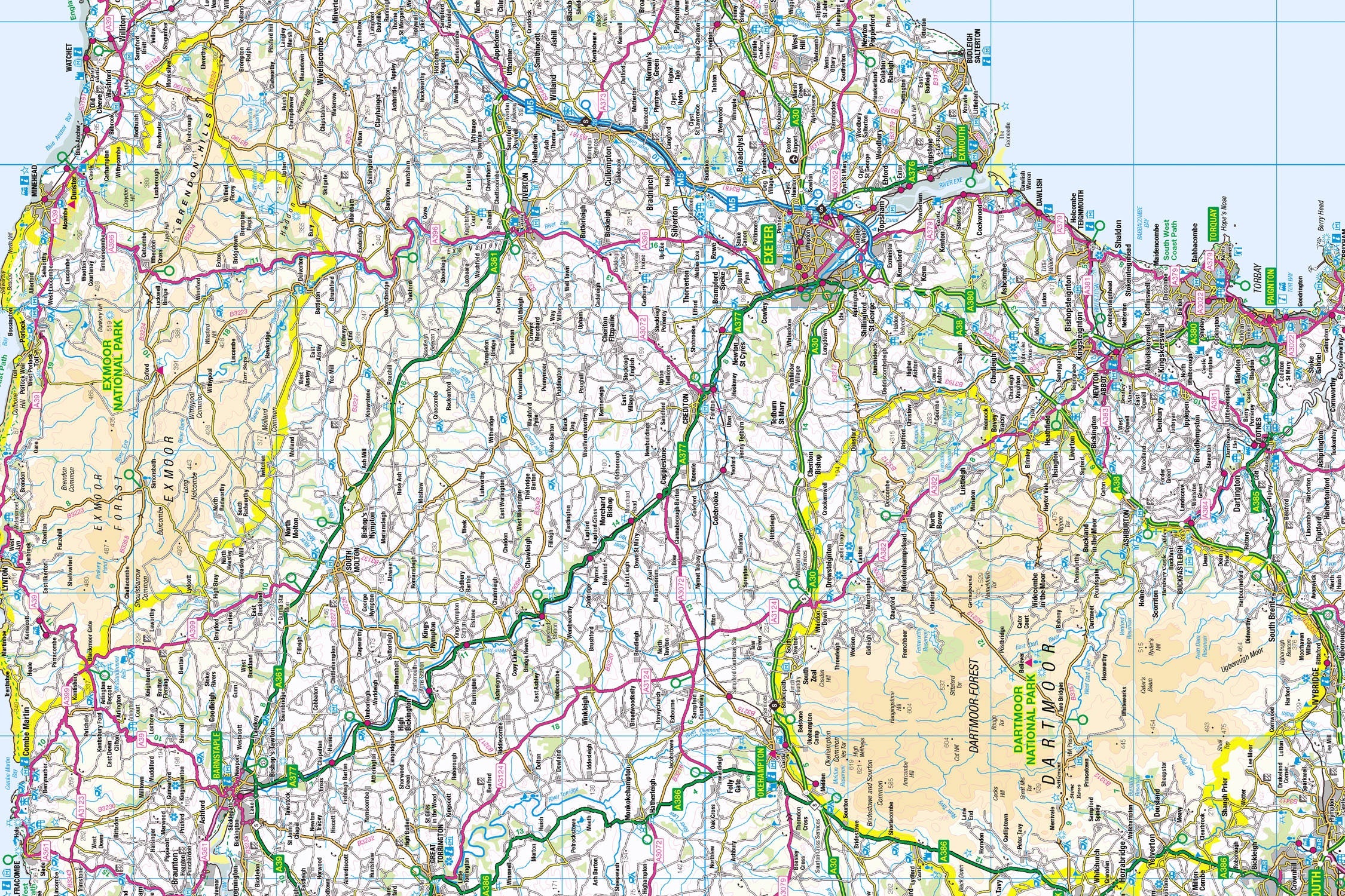
Introducing the Dartmoor and Exmoor Map Jigsaw
Pieceful Maps presents a unique cartographic adventure with our Dartmoor and Exmoor Map Jigsaw - the only puzzle in our collection featuring two national parks! This 1,000-piece challenge (69cm x 48cm assembled) transforms Ordnance Survey's 1:250,000 road map into a captivating journey through historic market towns, picturesque villages, and the precise boundaries of both parks. Created under the Open Government Licence, every road, settlement, and landmark is reproduced with cartographic clarity, offering double the discovery in one mindful experience.
Why Road Mapping Perfectly Fits Two Parks:
-
Complete Coverage: 635 square miles from Dartmoor's heart to Exmoor's coast
-
Settlement Clarity: All 50+ villages clearly labelled
-
Road Network Focus: Colour-coded routes simplify navigation
-
Boundary Precision: Distinctive borders for both parks
-
Landmark Visibility: Key attractions instantly recognisable
Dartmoor & Exmoor: Southwest Treasures
Neighbouring Yet Distinct
Though geographically close, these parks offer unique characters:
-
Dartmoor (designated 1951): Vast inland wilderness with ancient stone circles
-
Exmoor (designated 1954): Coastal heights meeting the Bristol Channel
Essential Moorland Data:
| Feature | Dartmoor | Exmoor |
|---|---|---|
| Key Towns | Okehampton, Tavistock | Lynmouth, Dulverton |
| Iconic Roads | A386, B3212 | A39 Atlantic Highway |
| Famous Landmarks | Dartmoor Prison, Haytor Vale | Tarr Steps, Dunkery Beacon |
| River Systems | Dart, Tavy, Teign | Exe, Barle, East Lyn |
| Visitor Centres | Princetown, Postbridge | Exford, Combe Martin |
Navigational Treasures
Assemble your puzzle to uncover these key features:
-
Dartmoor Icons: Princetown (historic prison town), Moretonhampstead (eastern gateway), Bovey Tracey (crafts market town)
-
Exmoor Highlights: Lynton & Lynmouth (twin coastal villages), Minehead (South West Coast Path start), Dunster (medieval castle village)
-
Connecting Routes: A30 (northern boundary), A38 (eastern access), A396 (Exe Valley corridor)
-
Cultural Landmarks: Castle Drogo (England's newest castle), Dunster Working Watermill, Clovelly Court Gardens
Mastering Dual-Park Puzzling
Strategic Assembly Approach
This unique twin-park puzzle offers clever solving opportunities:
-
Boundaries First: Connect Dartmoor's diamond shape and Exmoor's coastal outline
-
Road Anchors: Build the A30 (Dartmoor) and A39 (Exmoor) as structural spines
-
Town Clusters: Piece together Okehampton/Tavistock (Dartmoor) and Lynton/Dulverton (Exmoor)
-
River Networks: Follow the Dart and Exe rivers
-
Landmark Completion: Add castle symbols and visitor centres
Cognitive Benefits:
-
Spatial Awareness: Understanding how two distinct parks relate geographically
-
Pattern Recognition: Identifying road hierarchies across different terrains
-
Memory Exercise: Recalling relative positions of market towns
-
Mindful Focus: Achieving calm through "landscape connection"
Ordnance Survey: The Navigator's Gold Standard
Why OS Road Maps Excel
Our puzzles use official 1:250,000 data – perfect for exploring these landscapes:
-
Settlement Hierarchy: Clear distinction between towns, villages, and hamlets
-
Road Classification: Colour-coded from motorways to country lanes
-
Landmark Clarity: Castles, historic sites, and viewpoints prominently marked
-
Boundary Precision: Exact park perimeters maintained
"Contains public sector information licensed under the Open Government Licence - os.uk/opendata/licence"
Historical Note: Ordnance Survey first mapped this region during the Napoleonic Wars - today's roads often follow ancient drovers' paths.
The Pieceful Maps Experience
From Puzzle to Real-World Exploration
Your completed masterpiece becomes practical trip-planning artwork:
-
Preserve: Apply puzzle glue for permanent display
-
Frame: Choose a rustic oak frame (min 2cm depth)
-
Plan: Mark road trip routes with dry-wipe markers
-
Explore: Use your spatial knowledge to navigate both parks
Top Accessible Experiences:
-
Dartmoor Drive: B3212 across the moor's heart (Princetown to Moretonhampstead)
-
Exmoor Coastal Tour: A39 from Minehead to Lynmouth
-
Market Day: Tavistock Pannier Market (Dartmoor) or Dulverton Thursday Market (Exmoor)
-
Castle Visit: Castle Drogo (Dartmoor) or Dunster Castle (Exmoor)
Why Puzzlers Love This Twin Challenge
"This unique puzzle lets you explore Dartmoor's historic prison before breakfast and watch Exmoor's coastal sunset by teatime - all without leaving your living room! The perfect way to plan a real Southwest adventure." – Pieceful Maps Designer
The Mindful Mapping Journey
This 1,000-piece challenge delivers:
-
Digital Detox: 8-12 hours of screen-free immersion
-
Geographical Insight: Understand how neighbouring parks connect
-
Skill Development: Map literacy and spatial reasoning
-
Achievement High: Satisfaction of completing two national parks
-
Wall Art Reward: Striking dual-landscape display
Ready to explore Britain's wild southwest twins? Dartmoor and Exmoor await – one piece at a time.
About Pieceful Maps: We transform official Ordnance Survey data into captivating jigsaws celebrating Britain’s national parks.
Latest Product Reviews

A Proud Kase UK Partner
The use of high quality glass filters for landscape photography is quite simply game changing and will improve your resulting images. I am happy to talk filters and help you get started, start a conversation here
