


Conquer the Cairngorms: Your Arctic Wilderness Jigsaw Adventure
Piece Together Britain's Largest National Park
Key Highlights
-
Subarctic Majesty: Britain's largest national park with unique arctic-alpine terrain
-
Precision OS Mapping: 1:250,000 scale capturing all towns, roads & boundaries
-
1,000-Piece Challenge: 69cm x 48cm completed size
-
Open Government Licence: Authentic OS data reproduction
-
Mindful Puzzling: Combines wilderness appreciation with satisfying assembly
Cairngorms Map Jigsaw
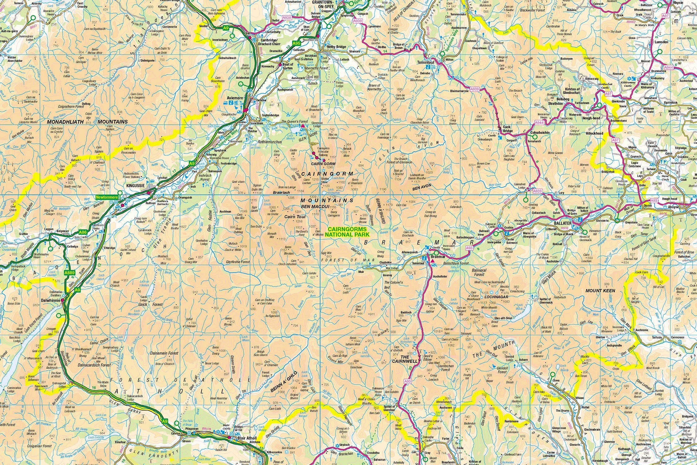
Pieceful Maps invites you to explore Scotland's mountain heart with our Cairngorms Map Jigsaw. This 1,000-piece puzzle (69cm x 48cm assembled) transforms Ordnance Survey's 1:250,000 roadmap into an epic journey through ancient Caledonian forests, subarctic plateaus, and whisky country. Created under the Open Government Licence, every settlement, road, and park boundary is reproduced with cartographic precision – perfect for wilderness lovers seeking Britain's most expansive protected landscape .
Why This Scale Fits the Highlands:
-
Complete Park Coverage: 1,748 square miles of Scottish Highlands
-
Settlement Clarity: All towns from Aviemore to Braemar clearly visible
-
Mountain Roads: Iconic passes like the Lecht and Glenshee
-
Boundary Definition: Distinctive park perimeter framing Britain's wildest terrain
The Cairngorms: Scotland's Arctic Wilderness
Land of Extremes
Designated in 2003 and expanded in 2010, this park protects 25% of Scotland's native forest and contains 5 of Britain's 6 highest peaks. Its subarctic plateau experiences tundra-like conditions year-round – unique in the UK .
Essential Highland Data:
| Feature | Detail |
|---|---|
| Highest Peaks | Ben Macdui (1,309m), Braeriach (1,296m) |
| Unique Wildlife | Reindeer herd, capercaillie, golden eagle |
| Forest Cover | 25% of Scotland's native woodland |
| Whisky Distilleries | 12 working distilleries |
| Winter Sports | 3 of Scotland's 5 ski resorts |
Navigational Treasures
Assemble your puzzle to uncover these iconic features:
-
Mountain Hubs: Aviemore (outdoor capital), Braemar (Royal Highland Gathering host), Tomintoul (highest village)
-
Iconic Routes: A939 "Snow Road", A93 through Glenshee, Speyside Way whisky trail
-
Natural Wonders: Loch Morlich (beach-surrounded loch), Rothiemurchus Forest, Linn of Dee
-
Cultural Landmarks: Balmoral Castle, Dalwhinnie Distillery, Highland Wildlife Park
Mastering Mountain Map Puzzling
Strategic Assembly Approach
This puzzle's vast scale offers rewarding solving stages:
-
Peaks First: Locate Ben Macdui and Braeriach summit symbols
-
Road Anchors: Connect the A9, A939, and A93 as transport spines
-
River Systems: Follow the Spey, Dee, and Don rivers
-
Settlement Clusters: Build Aviemore, Ballater, and Kingussie
-
Forest & Lochs: Complete Caledonian pine forests and major water bodies
Cognitive Benefits:
-
Spatial Reasoning: Visualising how glens connect mountains to lowlands
-
Pattern Recognition: Identifying whisky trail routes
-
Memory Exercise: Recalling relative positions of ancient forests
-
Mindful Focus: Achieving calm through "wilderness construction"
Ordnance Survey: The Highland Navigator's Trusted Guide
Why OS Maps Excel for Wilderness
Our puzzles use official 1:250,000 data – essential for this expansive terrain:
-
Access Clarity: Mountain passes and ski roads marked
-
Settlement Hierarchy: Clear distinction between towns and hamlets
-
Heritage Symbols: Highlights castles, distilleries, and viewpoints
-
Practical Detail: Shows ranger centres and emergency facilities
"Contains public sector information licensed under the Open Government Licence - os.uk/opendata/licence"
Historical Note: The Cairngorms were first surveyed by OS in 1869 using triangulation from Ben Nevis – a feat commemorated on modern maps.
The Pieceful Maps Experience
From Puzzle to Highland Adventure
Your completed masterpiece becomes practical expedition artwork:
-
Preserve: Apply puzzle glue for permanent display
-
Frame: Choose a pine-effect frame complementing forest tones
-
Plan: Mark hiking/whisky trails on the glass
-
Explore: Use your spatial knowledge to navigate the wilderness
Top Real-World Experiences:
-
Summit Challenge: Hike Ben Macdui via Loch Etchachan
-
Whisky Trail: Tour distilleries from Dalwhinnie to Tomintoul
-
Forest Immersion: Rothiemurchus red squirrel spotting
-
Winter Adventure: Skiing at Glenshee or Cairngorm Mountain
Why Puzzlers Love This Highland Challenge
"The Cairngorms puzzle lets you traverse Britain's highest plateau before breakfast, explore ancient pine forests by lunch, and warm up in a whisky distillery by teatime – all without braving the Scottish weather!" – Pieceful Maps Designer
The Mindful Mapping Journey
This 1,000-piece challenge delivers:
-
Digital Detox: 8-12 hours of screen-free immersion
-
Wilderness Connection: Tangible link to Britain's last wild places
-
Skill Development: Map literacy and spatial strategy
-
Achievement High: Triumph of completing Scotland's mountain heart
-
Wall Art Reward: Dramatic conversation piece for your home
Ready to explore Britain's last great wilderness? The Cairngorms await – one piece at a time.
About Pieceful Maps: We transform official Ordnance Survey data into captivating jigsaws celebrating Britain’s national parks.
Latest Product Reviews

A Proud Kase UK Partner
The use of high quality glass filters for landscape photography is quite simply game changing and will improve your resulting images. I am happy to talk filters and help you get started, start a conversation here
