


Navigate the Norfolk Broads: Your OS Waterways Jigsaw Adventure
Piece Together Britain's Magical Wetland Wonderland
Key Highlights
-
Unique Landscape: UK's largest protected wetland with 125 miles of navigable waterways
-
Precision OS Mapping: 1:250,000 scale capturing all rivers, broads & settlements
-
1,000-Piece Challenge: 69cm x 48cm completed size
-
Open Government Licence: Authentic OS data reproduction
-
Mindful Puzzling: Combines geography education with serene assembly
Introducing the Norfolk Broads Map Jigsaw
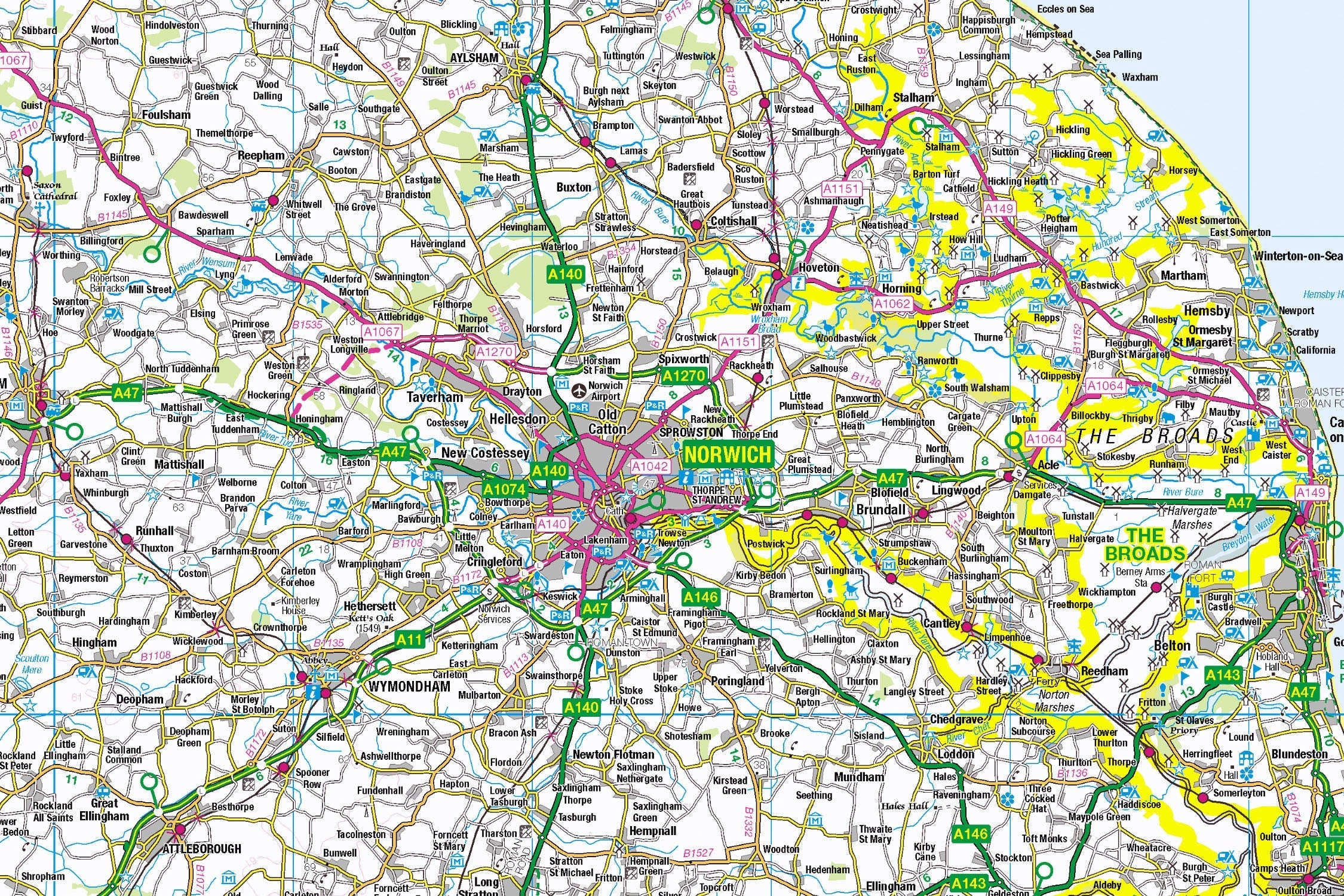
Pieceful Maps invites you to chart England's most unique wetland landscape with our Norfolk Broads Map Jigsaw. This 1,000-piece puzzle (69cm x 48cm assembled) transforms Ordnance Survey's definitive 1:250,000 roadmap into a captivating journey through meandering rivers, tranquil broads, and picturesque riverside villages. Created under the Open Government Licence, every waterway, footpath, and settlement is reproduced with cartographic precision – offering puzzle lovers and geography enthusiasts alike a peaceful yet engaging challenge.
Why This Scale Perfectly Fits:
-
Complete Park Coverage: 303 square kilometres of wetlands in one view
-
Waterway Clarity: All rivers, dykes, and broads distinctly marked
-
Settlement Visibility: Every waterside village from Wroxham to Beccles
-
Boundary Definition: National Park perimeter clearly defined
The Norfolk Broads: Britain's Waterland Kingdom
A Man-Made Natural Wonder
Designated in 1989, Britain's largest protected wetland is a paradox: its shimmering lakes ("broads") were created by medieval peat excavations. This 125-mile navigable network hosts over 2,500 years of human history alongside rare wildlife.
Essential Broads Data:
| Feature | Detail |
|---|---|
| Waterways | 125 navigable miles |
| Broads Count | 63 freshwater lakes |
| Wildlife | 400+ plant & 230+ bird species |
| Unique Status | National Park since 2015 |
| Conservation | Protects 28 Sites of Special Scientific Interest |
Navigational Treasures
Assemble your puzzle to uncover these iconic features:
-
Boating Capitals: Wroxham (gateway village), Potter Heigham (historic bridge challenge), Beccles (southern hub)
-
Iconic Broads: Barton Broad (second largest), Hickling Broad (nature reserve), Salhouse Broad (secret swimming spot)
-
Rivers & Dykes: River Bure (arterial waterway), River Yare (southern route), River Ant (wildlife corridor)
-
Cultural Landmarks: Horsey Windpump (National Trust treasure), St. Benet's Abbey (ruined riverside monastery)
Mastering Waterway Map Puzzling
Strategic Assembly Approach
Water-dominated maps offer unique solving dynamics with their intricate blue networks:
-
River Anchors First: Connect the primary waterways (Bure, Yare, Ant) as structural spines
-
Broads Cluster: Piece together the larger lakes like Barton and Hickling
-
Settlement Links: Build waterside villages connected by ferry routes
-
Boundary Completion: Use the distinctive park perimeter for orientation
-
Symbol Highlights: Add windmills, nature reserves, and mooring spots
Cognitive Benefits:
-
Spatial Intelligence: Visualising how rivers connect villages to broads
-
Pattern Recognition: Identifying navigable vs non-navigable waterways
-
Memory Exercise: Recalling relative positions of iconic windmills
-
Mindful Focus: Achieving calm through "blue space" assembly
Ordnance Survey: The Water Navigator's Bible
Why OS Maps Excel for Waterways
Our puzzles use official 1:250,000 data – ideal for wetland navigation:
-
Waterway Hierarchy: Distinguishes rivers, broads, and dykes
-
Access Points: Marks moorings, staithes, and slipways
-
Heritage Symbols: Highlights windpumps and historic sites
-
Practical Detail: Shows footpaths along riverbanks
"Contains public sector information licensed under the Open Government Licence - os.uk/opendata/licence"
Historical Note: The Broads were only recognised as artificial features in the 1960s when aerial photos revealed their medieval origins – a secret mapped beautifully in OS data.
The Pieceful Maps Experience
From Puzzle to Real Adventure
Your completed masterpiece becomes practical trip-planning artwork:
-
Preserve: Apply puzzle glue for permanent display
-
Frame: Choose a light oak frame to complement waterways
-
Plan: Mark canoe routes on the glass with dry-wipe pens
-
Explore: Use your spatial knowledge to navigate the network
Top Real-World Experiences:
-
Sunrise Canoe: Paddle the Ant Trail at dawn for otter sightings
-
Sailing Adventure: Charter a day boat from Wroxham
-
Wildlife Walk: Bittern Trail at Hickling Broad nature reserve
-
Historic Pub Crawl: Waterside inns along the Bure
Why Puzzlers Love This Watery Challenge
"The Broads puzzle turns armchair navigation into geographical poetry. Where else can you trace heron flight paths at breakfast, plan a lunchtime pub mooring by coffee, and spot your sunset viewing windpump before tea?" – Pieceful Maps Designer
The Mindful Mapping Journey
This 1,000-piece challenge delivers:
-
Digital Detox: 8-12 hours of screen-free tranquillity
-
Family Bonding: Collaborative waterway assembly
-
Skill Development: Map literacy and navigation skills
-
Achievement High: Triumph of completing Britain's water labyrinth
-
Wall Art Reward: Serene display piece for home or office
Ready to navigate England's magical wetland? The Norfolk Broads await – one piece at a time.
About Pieceful Maps: We transform official Ordnance Survey data into captivating jigsaws celebrating Britain’s national parks.
Latest Product Reviews

A Proud Kase UK Partner
The use of high quality glass filters for landscape photography is quite simply game changing and will improve your resulting images. I am happy to talk filters and help you get started, start a conversation here
