


Conquer Snowdonia: Your OS Mountain Map Jigsaw Adventure
Piece Together Wales' Iconic Peaks and Passes
Key Highlights
-
Dramatic Terrain: Home to Wales' highest peak and deepest natural lake
-
Precision OS Mapping: 1:250,000 scale capturing all towns, roads & park boundaries
-
1,000-Piece Challenge: 69cm x 48cm completed size
-
Open Government Licence: Authentic OS data reproduction
-
Mindful Puzzling: Combines geography mastery with satisfying assembly
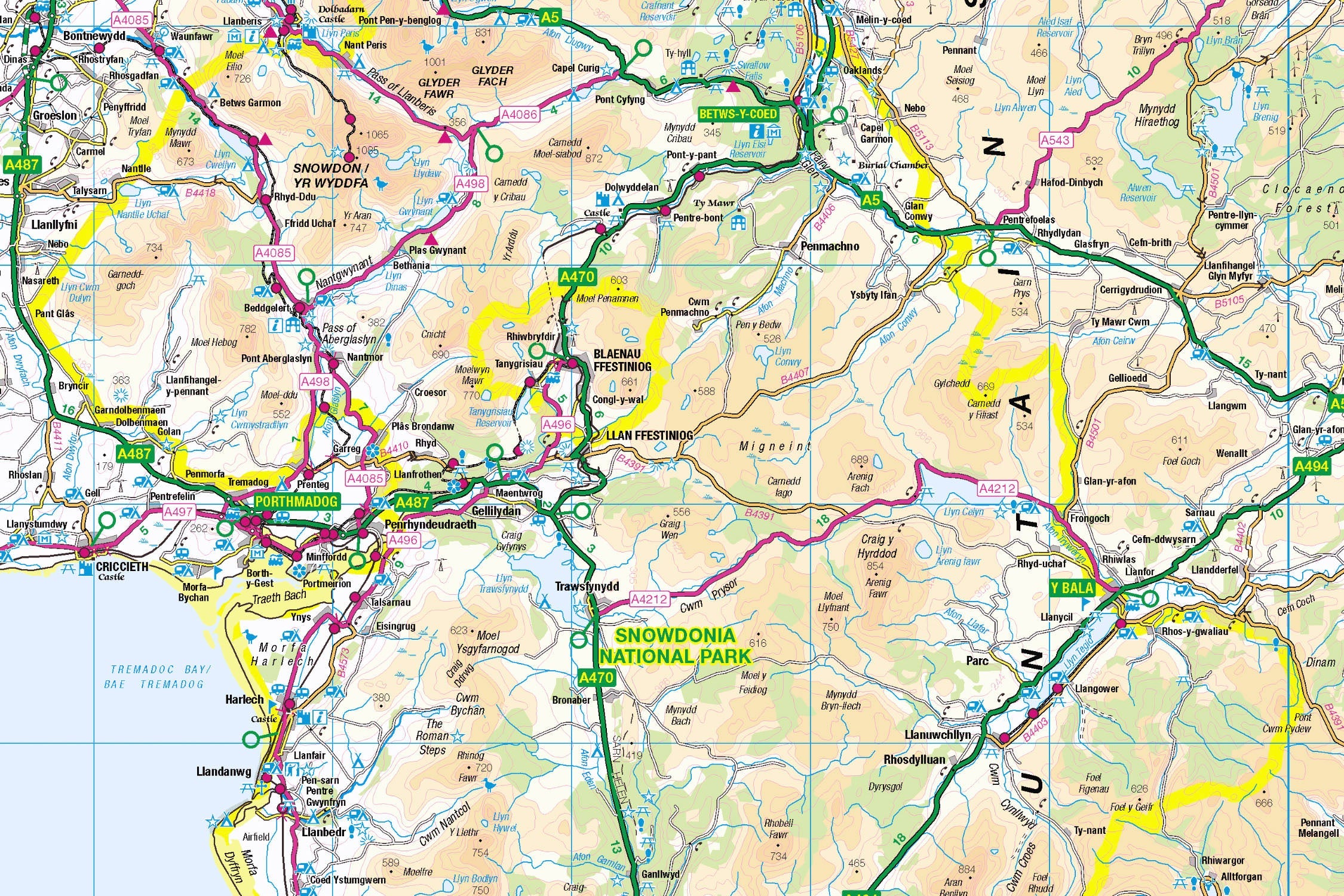
Introducing the Snowdonia Map Jigsaw
Pieceful Maps invites you to summit Wales' most legendary landscape with our Snowdonia Map Jigsaw. This 1,000-piece puzzle (69cm x 48cm assembled) transforms Ordnance Survey's definitive 1:250,000 roadmap into an exhilarating journey through mountain passes, glacial valleys, and coastal villages. Created under the Open Government Licence, every road, settlement, and park boundary is reproduced with cartographic precision – offering mountaineers and puzzle enthusiasts alike a rewarding challenge.
Why This Scale Captures Majesty:
-
Complete Park Coverage: 823 square miles from coast to peaks
-
Settlement Clarity: All villages from Betws-y-Coed to Bala clearly visible
-
Road Network Focus: Colour-coded routes through challenging terrain
-
Boundary Definition: Distinctive national park perimeter
Snowdonia: Wales' Mountain Kingdom
Land of Legends
Established in 1951 as Wales' first national park, Snowdonia (Eryri) protects 2,142 km² of glaciated valleys, 15 mountain ranges, and 23 miles of coastline. Its cultural significance matches its physical drama – this is where King Arthur's knights slumber and where Welsh language and traditions thrive .
Essential Snowdonia Data:
| Feature | Detail |
|---|---|
| Highest Peak | Yr Wyddfa (Snowdon) - 1,085m |
| Mountain Ranges | 15 distinct groups |
| Lakes | 200+ including Llyn Tegid (deepest) |
| Language | 80% Welsh-speaking communities |
| UNESCO Status | Global Geopark since 2005 |
Navigational Treasures
Assemble your puzzle to uncover these iconic features:
-
Mountain Hubs: Betws-y-Coed (adventure capital), Llanberis (Snowdon gateway), Blaenau Ffestiniog (slate mining heritage)
-
Legendary Routes: A5 (historic Telford road), A4086 (Llanberis Pass), Ffordd Pen Llech (world's steepest street)
-
Cultural Icons: Harlech Castle (UNESCO fortress), Portmeirion (Italianate village), Ffestiniog Railway (heritage steam line)
-
Coastal Gems: Barmouth (Victorian seaside resort), Fairbourne (beach railway)
Mastering Mountain Map Puzzling
Strategic Assembly Approach
Mountain maps offer unique solving challenges with their radial road patterns:
-
Peak First: Start with Snowdon's summit symbol and radiating paths
-
Road Anchors: Connect the A5 and A487 as primary transport spines
-
Valley Network: Piece together glacial valleys (Nant Gwynant, Ogwen)
-
Coast & Towns: Build coastal settlements before linking mountain villages
-
Heritage Lines: Add railway routes (Ffestiniog, Snowdon Mountain Railway)
Cognitive Benefits:
-
Spatial Reasoning: Visualising how valleys connect peaks to coast
-
Pattern Recognition: Identifying pass routes vs valley roads
-
Memory Exercise: Recalling relative positions of iconic castles
-
Mindful Focus: Achieving flow state through "landscape construction"
Ordnance Survey: The Mountaineer's Trusted Guide
Why OS Maps Excel for Mountains
Our puzzles use official 1:250,000 data – ideal for mountain navigation:
-
Pass Identification: Critical mountain routes clearly marked
-
Settlement Hierarchy: Distinguishes towns vs isolated hamlets
-
Heritage Symbols: Highlights castles, railways, and viewpoints
-
Practical Detail: Shows parking areas and visitor centres
"Contains public sector information licensed under the Open Government Licence - os.uk/opendata/licence"
Historical Note: Snowdon's summit was first triangulated by Ordnance Survey in 1824 – establishing it as Wales' highest point .
The Pieceful Maps Experience
From Puzzle to Real Adventure
Your completed masterpiece becomes practical expedition artwork:
-
Preserve: Apply puzzle glue for permanent display
-
Frame: Choose a slate-effect frame honouring local heritage
-
Plan: Mark hiking routes on the glass with dry-wipe pens
-
Conquer: Use your spatial knowledge to tackle iconic peaks
Top Real-World Experiences:
-
Summit Challenge: Hike Snowdon via Crib Goch (Grade 1 scramble)
-
Railway Journey: Take the Snowdon Mountain Railway from Llanberis
-
Coastal Adventure: Walk the Mawddach Trail from Barmouth to Dolgellau
-
Cultural Immersion: Explore Portmeirion's Mediterranean fantasy
Why Puzzlers Love This Mountain Challenge
"The Snowdonia puzzle turns armchair exploration into geographical triumph. Where else can you conquer Yr Wyddfa before breakfast, navigate the Llanberis Pass by lunch, and reach Harlech Castle by teatime – all without breaking sweat?" – Pieceful Maps Designer
The Mindful Mapping Journey
This 1,000-piece challenge delivers:
-
Digital Detox: 8-12 hours of screen-free immersion
-
Family Bonding: Collaborative peak-bagging fun
-
Skill Development: Map literacy and terrain analysis
-
Achievement High: Triumph of completing Wales' rooftop
-
Wall Art Reward: Dramatic display piece for your home
Ready to summit Wales' majestic rooftop? Snowdonia awaits – one piece at a time.
About Pieceful Maps: We transform official Ordnance Survey data into captivating jigsaws celebrating Britain’s national parks.
Latest Product Reviews

A Proud Kase UK Partner
The use of high quality glass filters for landscape photography is quite simply game changing and will improve your resulting images. I am happy to talk filters and help you get started, start a conversation here
