


Discover Loch Lomond & The Trossachs: Your Highland Lake District Jigsaw Adventure
Piece Together Scotland's First National Park
Key Highlights
-
Pioneering Status: Scotland's inaugural national park (2002)
-
Precision OS Mapping: 1:250,000 scale capturing all lochs, islands & settlements
-
1,000-Piece Challenge: 69cm x 48cm completed size
-
Open Government Licence: Authentic OS data reproduction
-
Mindful Puzzling: Combines loch navigation with serene assembly
Loch Lomond & The Trossachs Map Jigsaw
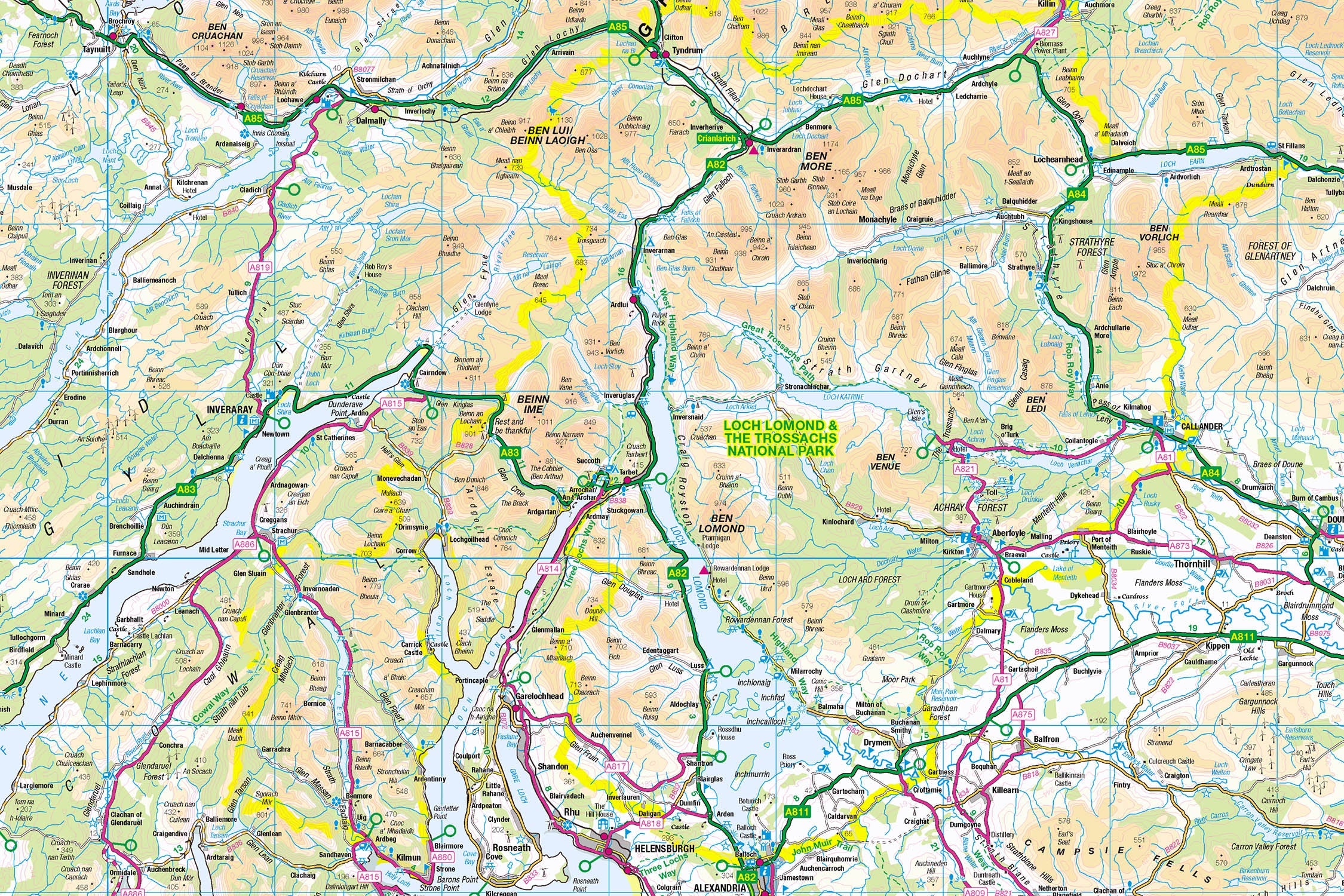
Pieceful Maps invites you to explore Scotland's iconic lake district with our Loch Lomond and The Trossachs Map Jigsaw. This 1,000-piece puzzle (69cm x 48cm assembled) transforms Ordnance Survey's 1:250,000 roadmap into a captivating journey through misty glens, island-studded lochs, and historic Highland towns. Created under the Open Government Licence, every shoreline, settlement, and park boundary is reproduced with cartographic precision – offering a mindful voyage into Scotland's most accessible wilderness.
Why This Scale Fits the Lochs:
-
Complete Park Coverage: 720 square miles from Argyll to Perthshire
-
Island Clarity: 60+ Loch Lomond islands clearly visible
-
Settlement Detail: All villages from Luss to Callander
-
Route Precision: Three Lochs Forest Drive distinctly marked
Loch Lomond and The Trossachs: Gateway to the Highlands
Scotland's Liquid Heart
Established in 2002 as Scotland's first national park, this landscape protects 22 lochs, 21 Munros, and the largest inland body of water in Britain. Its accessibility from Glasgow makes it Scotland's most visited wilderness, drawing 4 million annual visitors.
Essential Park Data:
| Feature | Detail |
|---|---|
| Loch Lomond | 24 miles long with 60+ islands |
| Ben Lomond | Most southerly Munro (974m) |
| Woodland | 50% of Britain's ancient oakwoods |
| Historic Routes | West Highland Way & Rob Roy Way |
| Unique Geology | Highland Boundary Fault visible |
Navigational Treasures
Assemble your puzzle to uncover these iconic features:
-
Lochside Villages: Luss (picture-perfect conservation village), Tarbet (walking hub), Balquhidder (Rob Roy's grave)
-
Legendary Lochs: Loch Katrine (Walter Scott's inspiration), Loch Earn (watersports paradise), Loch Venachar (fishing haven)
-
Mountain Passes: Dukes Pass (dramatic viewpoint road), Rest and Be Thankful (historic military route)
-
Cultural Icons: Inchmahome Priory (Mary Queen of Scots refuge), Bracklinn Falls, The Lodge Forest Visitor Centre
Mastering Lakeside Map Puzzling
Strategic Assembly Approach
This puzzle's intricate shoreline offers rewarding solving stages:
-
Loch Lomond First: Piece together Britain's largest loch shoreline
-
Island Cluster: Build Inchmurrin, Inchcailloch, and Bucinch islands
-
Route Anchors: Connect A82 (western shore) and A81 (Trossachs spine)
-
Settlement Hubs: Complete Balloch, Callander, and Aberfoyle
-
Mountain Framing: Add Ben Lomond and Ben Venue summit symbols
Cognitive Benefits:
-
Spatial Navigation: Visualising how lochs connect via glens
-
Pattern Recognition: Identifying ferry routes between islands
-
Memory Exercise: Recalling relative positions of ancient oakwoods
-
Mindful Focus: Achieving calm through "shoreline construction"
Ordnance Survey: The Loch Navigator's Essential
Why OS Maps Excel for Lake Districts
Our puzzles use official 1:250,000 data – perfect for this water-dominated landscape:
-
Shoreline Precision: Every bay and promontory accurately rendered
-
Island Detail: All 60+ Loch Lomond islands labelled
-
Access Points: Marks piers, ferry terminals, and watersports centres
-
Practical Symbols: Highlights viewpoints and visitor centres
"Contains public sector information licensed under the Open Government Licence - os.uk/opendata/licence"
Historical Note: OS first mapped Loch Lomond in 1819 using pioneering boat-based triangulation – techniques still visible in modern mapping.
The Pieceful Maps Experience
From Puzzle to Lochside Adventure
Your completed masterpiece becomes practical voyage-planning artwork:
-
Preserve: Apply puzzle glue for permanent display
-
Frame: Choose a driftwood or oak frame
-
Plan: Mark sailing routes on the glass with dry-wipe pens
-
Explore: Use your spatial knowledge to navigate the lochs
Top Real-World Experiences:
-
Island Hopping: Cruise Loch Lomond to Inchcailloch's oakwoods
-
Munro Ascent: Hike Ben Lomond via Ptarmigan Ridge
-
Literary Journey: Walter Scott's Loch Katrine steamship tour
-
Forest Drive: Three Lochs Forest Trail at golden hour
Why Puzzlers Love This Lochside Challenge
"This puzzle lets you sail Loch Lomond's islands before breakfast, hike the Trossachs glens by lunch, and watch sunset over Ben Lomond by teatime – all without getting your feet wet!" – Pieceful Maps Designer
The Mindful Mapping Journey
This 1,000-piece challenge delivers:
-
Digital Detox: 8-12 hours of screen-free tranquillity
-
Family Bonding: Collaborative loch navigation
-
Skill Development: Map literacy and spatial strategy
-
Achievement High: Triumph of completing Scotland's lake district
-
Wall Art Reward: Stunning conversation piece for your home
Ready to explore Scotland's liquid heart? Loch Lomond & The Trossachs await – one piece at a time.
About Pieceful Maps: We transform official Ordnance Survey data into captivating jigsaws celebrating Britain’s 15 national parks across 14 puzzles.
Latest Product Reviews

A Proud Kase UK Partner
The use of high quality glass filters for landscape photography is quite simply game changing and will improve your resulting images. I am happy to talk filters and help you get started, start a conversation here
