Property listings without aerial perspectives leave potential guests guessing about context, surroundings, and true property scale. Aerial property photography eliminates this blind spot by revealing what ground-level shots physically cannot capture: proximity to places of interest, landscape setting, parking arrangements, and outdoor amenities in a single frame. For holiday cottages in the Peak District, hotels near hiking trails, or commercial properties with extensive grounds, drone photography shifts listings from adequate to compelling.
Table of Contents
- Quick Takeaways
- The Visibility Problem Ground Shots Cannot Solve
- How Drone Photography Increases Booking Confidence
- Practical Applications for Peak District Properties
- Technical Execution That Delivers Results
- Comparing Aerial Approaches for Property Marketing
- Frequently Asked Questions
- References
Quick Takeaways
| Key Insight | Explanation |
|---|---|
| Context sells properties faster | Aerial shots reveal location relationships ground photos cannot show, reducing guest uncertainty about distances to amenities and points of interest |
| Scale perception drives pricing power | Properties with extensive grounds, multiple buildings, or large outdoor spaces appear more valuable when captured from above |
| Competitive listings use drone imagery | Properties without aerial photography compete at a disadvantage against listings that show comprehensive visual context |
| Seasonal variation maximizes impact | Capturing drone imagery across seasons demonstrates year-round appeal and landscape changes that attract different guest segments |
| Destination marketing benefits multiply | Tourism boards and attractions use drone photography to showcase regional context, driving both direct bookings and area-wide visitor interest |
The Visibility Problem Ground Shots Cannot Solve
Ground-level photography captures interiors and immediate exteriors competently. It fails at spatial relationships. A holiday cottage listing with beautiful interior shots still leaves guests wondering: How far is parking? Where are neighboring properties? What does the surrounding landscape actually look like?
In practice, this information gap creates booking hesitation. Guests comparing ten similar cottages will favor the one that answers these questions visually. The property without aerial context forces potential bookers to study maps, read lengthy descriptions, and still make educated guesses about what they’re booking.
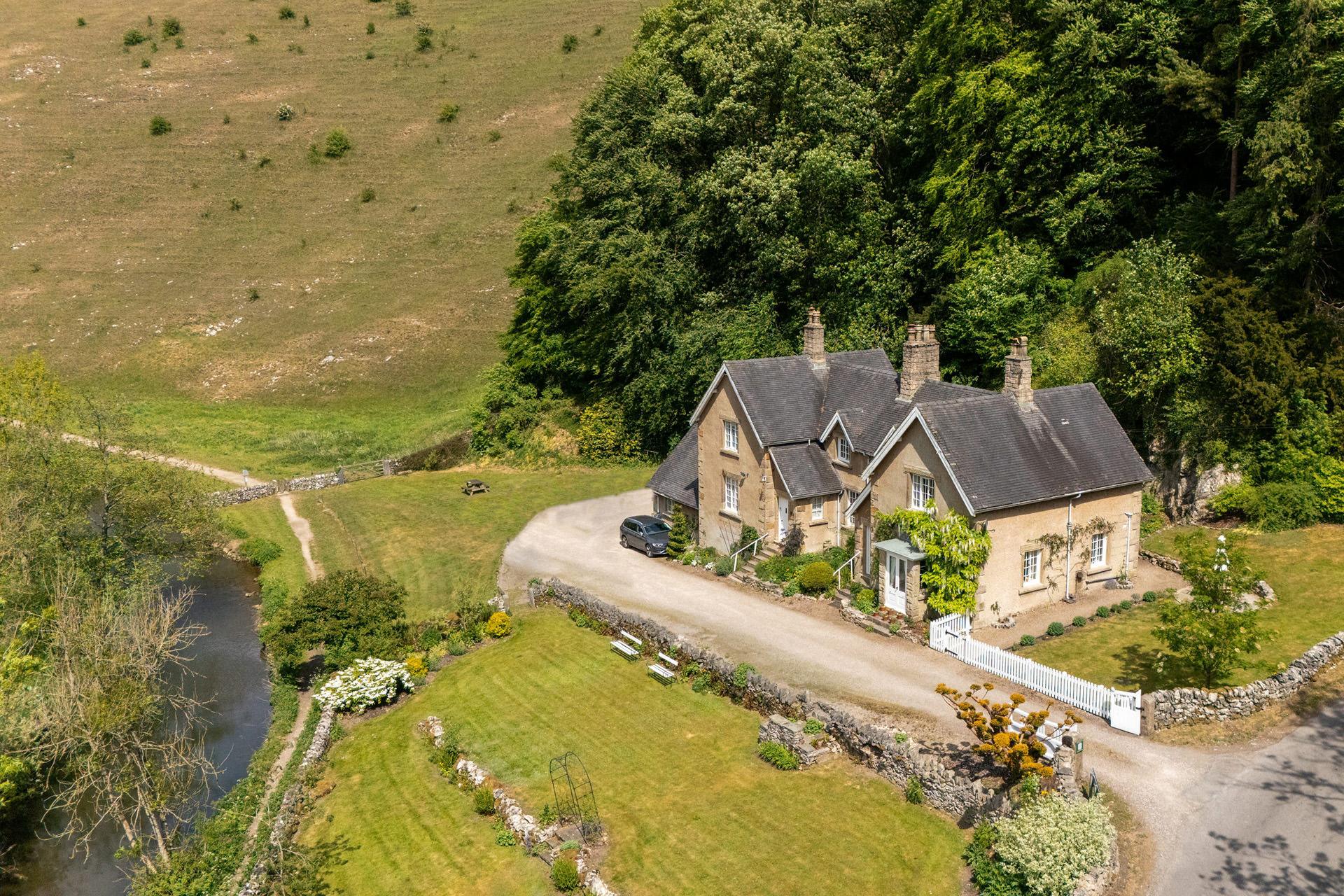
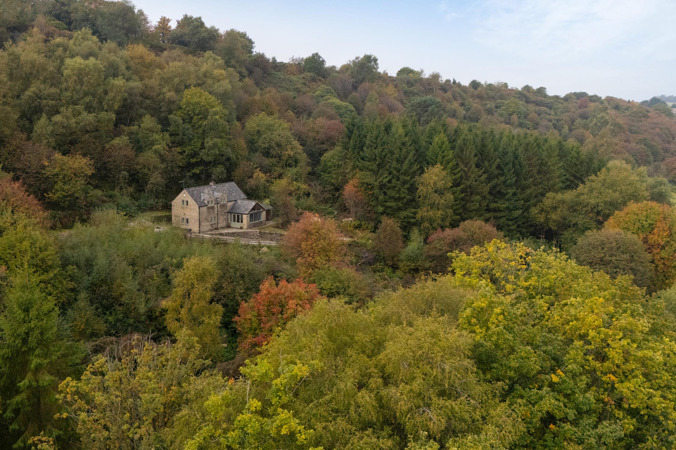
Drone photography solves this by providing the establishing shot that ground cameras cannot physically achieve. A single aerial image reveals parking arrangements, garden boundaries, proximity to roads or trails, and the property’s relationship to the broader landscape. For Peak District properties where location context matters tremendously, this visual information directly influences booking decisions.
Why Traditional Photography Leaves Money on the Table
Properties with significant outdoor space, multiple buildings, or unique landscape settings suffer most from ground-only photography. A barn conversion with three separate accommodation units appears confusing in ground shots. An aerial view clarifies the layout instantly.
Hotels and pubs with beer gardens, terraces, or outdoor dining areas struggle to convey scale and atmosphere without elevated perspectives. Ground shots fragment the space into disconnected images. Aerial photography unifies these elements into a coherent visual story that communicates capacity and appeal.
Pro tip: Properties near recognizable Peak District landmarks should include aerial shots that show this proximity. Guests booking countryside accommodation want visual confirmation they’re actually in the landscape they’ve chosen, not just near it.
How Drone Photography Increases Booking Confidence
Booking confidence stems from information completeness. The more questions a listing answers before contact, the higher the conversion rate. Aerial property photography addresses the spatial and contextual questions that text descriptions handle poorly.
According to research on property marketing, listings with aerial imagery receive measurably higher engagement rates. The data consistently shows that viewers spend more time on listings with comprehensive visual information, and time spent correlates directly with booking likelihood.
Properties that demonstrate complete transparency about location, surroundings, and spatial relationships convert browsers into bookers more efficiently than listings requiring guests to imagine or infer these details.
The Psychology of Visual Completeness
Humans make faster decisions when information feels complete. A property listing with only interior shots triggers subconscious questions about what’s being hidden or omitted. Aerial photography signals transparency and confidence in the product.
For holiday property owners, this psychological factor directly affects booking rates. Guests comparing similar properties will unconsciously favor listings that provide visual answers to unasked questions. The property with aerial context appears more professional, more trustworthy, and more worth the asking price.
Property listings compete not just on amenities but on information clarity. Two cottages with identical features at identical prices will see different booking rates based purely on how completely they communicate their offering. Aerial photography closes information gaps that cost bookings.
Practical Applications for Peak District Properties
Peak District properties benefit from aerial photography in specific, measurable ways that directly support booking objectives. The landscape itself becomes a marketing asset when captured properly from elevated angles.
Holiday Cottages and Self-Catering Properties
Cottages in rural locations need to demonstrate isolation without suggesting inconvenience. Aerial shots show the balance: surrounded by countryside but with visible road access and parking. For properties near popular walking routes like the Monsal Trail or Stanage Edge, drone photography can include these landmarks in frame, proving proximity claims with visual evidence.
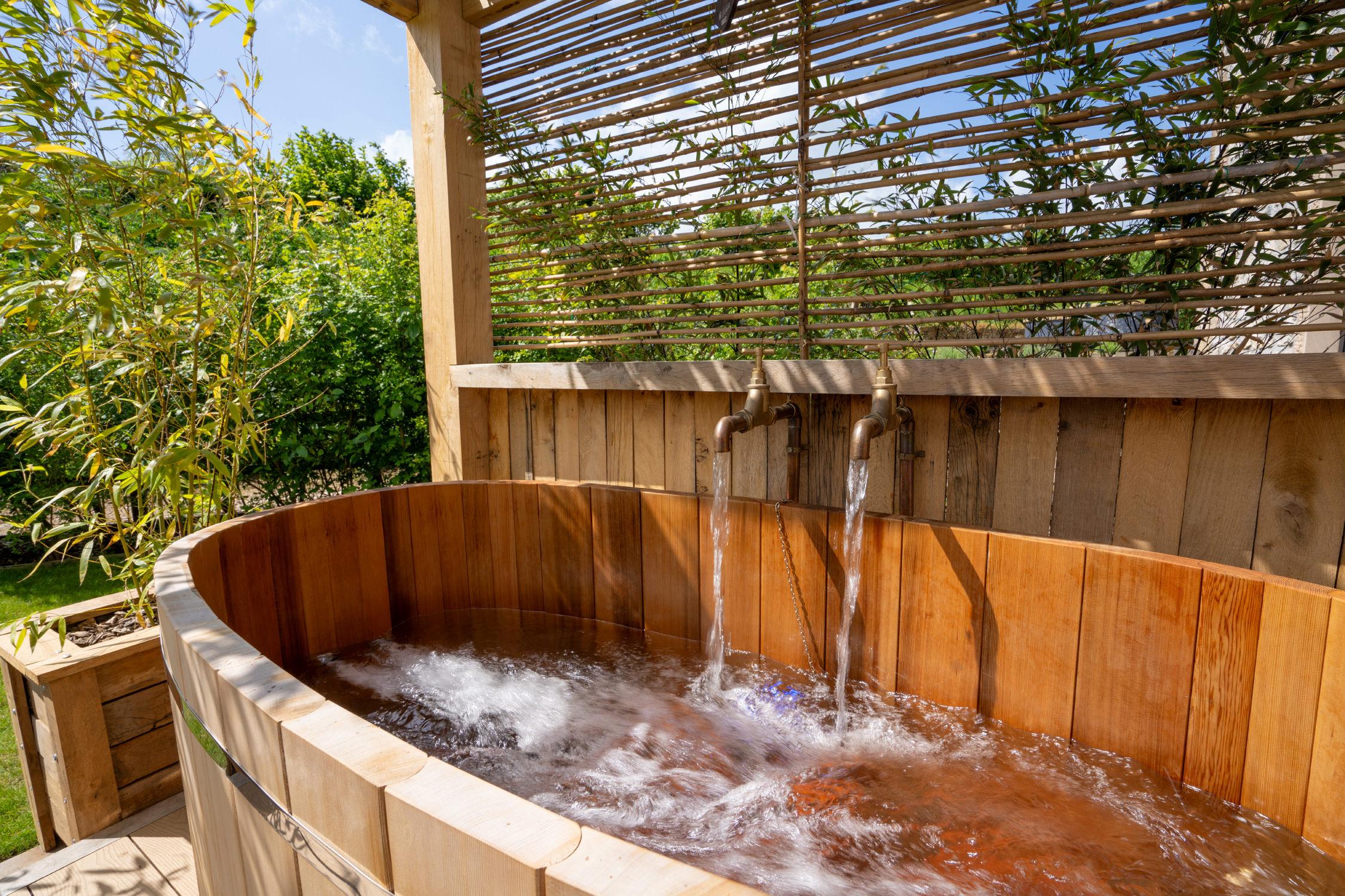
Gardens, hot tubs, and outdoor seating areas appear more appealing from above. Ground shots of gardens often look cramped or fail to show boundaries. Aerial perspectives reveal the full extent of private outdoor space, a significant selling point for groups and families.
Hotels and Hospitality Venues
Hotels benefit from aerial photography that shows their position within villages or near attractions. A hotel in Bakewell or Castleton gains credibility when aerial shots demonstrate its central location and proximity to visitor amenities. Parking capacity, outdoor dining areas, and facility scale all communicate more effectively from above.
Pubs with accommodation need to show their beer gardens, car parks, and outdoor spaces in context. Ground photography fragments these areas into separate images. Aerial shots unify them into a single compelling view that communicates atmosphere and capacity for events or group bookings.
Tourism Attractions and Destination Marketing
Visitor attractions using aerial photography for marketing materials benefit from dramatic landscape context that positions them within the Peak District brand. Stately homes, adventure parks, or heritage sites gain visual impact when shown against the surrounding moorland, valleys, or woodlands.
Tourism boards and destination marketing organizations use drone footage to create cohesive regional narratives. A single aerial shot can communicate Peak District character more effectively than paragraphs of description, supporting campaigns that drive visitor numbers across multiple properties and attractions.
Pro tip: Commission aerial photography during optimal seasonal conditions for your property type. Spring and summer showcase gardens and green landscapes, while autumn colors and winter light create dramatic moorland imagery that appeals to different guest segments.
Technical Execution That Delivers Results
Not all aerial photography delivers equal marketing value. Technical execution determines whether drone images enhance listings or simply add irrelevant sky shots. Professional drone photography requires specific knowledge about angles, lighting, and compositional choices that serve marketing objectives.
Altitude and Angle Selection
Most effective property aerials shoot from 20 to 60 meters altitude. Lower captures more detail but less context. Higher shows broader landscape but reduces property prominence. The optimal altitude depends on property size, surrounding features, and marketing purpose.
Angle matters as much as altitude. Straight-down orthogonal views work for site plans and property boundary documentation. Oblique angles at 30 to 45 degrees showcase buildings, grounds, and context simultaneously. This three-quarter perspective creates depth and visual interest while maintaining clarity about spatial relationships.
Lighting and Weather Conditions
Golden hour lighting transforms ordinary property exteriors into compelling imagery. Early morning and late afternoon sun creates texture, depth, and warmth that midday overhead light eliminates. Professional drone photographers schedule shoots around light quality, not just weather.
Weather considerations extend beyond avoiding rain. Cloud cover affects landscape drama. Partly cloudy skies add visual interest and texture. Completely clear skies can appear flat and uninteresting. The best aerial property photography balances clear visibility with atmospheric depth.
Comparing Aerial Approaches for Property Marketing
| Approach | Best Use Case | Limitations |
|---|---|---|
| Standard Drone Photography | Individual properties, hotels, cottages needing context and spatial relationship documentation | Single-visit captures only current seasonal conditions; weather-dependent scheduling |
| Seasonal Aerial Series | High-value properties wanting to demonstrate year-round appeal across seasonal landscape changes | Requires multiple shoot days across calendar year; higher investment but superior marketing versatility |
Each approach serves different marketing objectives and property types. Holiday cottages typically need standard drone photography showing context and surroundings. Large hotels or estates with multiple amenity areas benefit from aerial virtual tours that guide viewers through the property systematically.
Seasonal aerial series provide maximum marketing flexibility. Properties can rotate hero images across booking platforms to match current conditions, demonstrate seasonal attractions, or target specific guest segments attracted to particular times of year. A cottage showcasing autumn color appeals differently than the same property surrounded by spring wildflowers.
Frequently Asked Questions
What weather conditions work best for aerial property photography?
Partly cloudy conditions with good visibility produce the most visually interesting aerial imagery. Completely clear skies often appear flat and lack depth, while overcast conditions can look dull. Light wind below 15mph allows stable flying and sharp images. Golden hour lighting in early morning or late afternoon creates warmth and texture that enhances property appeal. Professional photographers monitor weather forecasts closely and reschedule when conditions compromise image quality.
How many aerial shots does a property listing need?
Most effective property listings include three to five aerial images showing different perspectives and distances. Wide establishing shots demonstrate location context and surroundings. Medium-range aerials show property layout, gardens, and parking. Closer elevated angles capture architectural details and outdoor amenity areas. This variety answers different guest questions about context, scale, and features without overwhelming the listing with repetitive imagery.
How does aerial photography affect property booking rates?
Properties adding professional aerial photography to listings typically see increased engagement time and improved conversion rates, though exact percentages vary by property type and competitive context. The impact is strongest for properties where location context, outdoor space, or surrounding landscape represents significant value. Cottages near attractions, hotels with extensive grounds, or properties in scenic settings benefit most measurably from aerial imagery that communicates these advantages visually.
Should properties update aerial photography seasonally?
High-value properties marketing year-round availability benefit significantly from seasonal aerial updates. Peak District landscapes change dramatically across seasons, and imagery matching current booking periods creates stronger guest connection. Properties focusing on specific seasons can prioritize aerial photography during peak visual appeal periods. Spring bluebells, summer green valleys, autumn moorland colors, and winter snow each attract different guest segments and justify seasonal image updates for properties targeting these markets.